You are here: Home > Network List > II - Global Seismograph Network (GSN - IRIS/IDA) Stations List
> Station XPFO Pinon Flat, California, USA > Earthquake Result Viewer
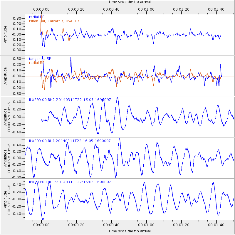
XPFO Pinon Flat, California, USA - Earthquake Result Viewer
*The percent match for this event was below the threshold and hence no stack was calculated.
| Earthquake location: |
Bismarck Sea |
| Earthquake latitude/longitude: |
-3.1/148.6 |
| Earthquake time(UTC): |
2014/03/11 (070) 22:03:09 GMT |
| Earthquake Depth: |
7.0 km |
| Earthquake Magnitude: |
6.1 MWW, 6.1 MWC, 6.1 MWB, 6.2 MWC |
| Earthquake Catalog/Contributor: |
NEIC PDE/NEIC COMCAT |
|
| Network: |
II Global Seismograph Network (GSN - IRIS/IDA) |
| Station: |
XPFO Pinon Flat, California, USA |
| Lat/Lon: |
33.61 N/116.46 W |
| Elevation: |
1280 m |
|
| Distance: |
95.9 deg |
| Az: |
56.691 deg |
| Baz: |
270.187 deg |
| Ray Param: |
$rayparam |
*The percent match for this event was below the threshold and hence was not used in the summary stack. |
|
| Radial Match: |
38.347015 % |
| Radial Bump: |
337 |
| Transverse Match: |
74.370186 % |
| Transverse Bump: |
400 |
| SOD ConfigId: |
626651 |
| Insert Time: |
2014-04-21 03:48:07.078 +0000 |
| GWidth: |
2.5 |
| Max Bumps: |
400 |
| Tol: |
0.001 |
|
Signal To Noise
| Channel | StoN | STA | LTA |
| II:XPFO:00:BHZ:20140311T22:16:05.169009Z | 0.65676576 | 1.7759183E-7 | 2.704036E-7 |
| II:XPFO:00:BH1:20140311T22:16:05.169009Z | 2.203254 | 3.7345688E-7 | 1.6950243E-7 |
| II:XPFO:00:BH2:20140311T22:16:05.169009Z | 2.1313157 | 2.9306995E-7 | 1.3750659E-7 |
| Arrivals |
| Ps | |
| PpPs | |
| PsPs/PpSs | |


