You are here: Home > Network List > TA - USArray Transportable Network (new EarthScope stations) Stations List
> Station TPFO Pinon Flats, CA, USA > Earthquake Result Viewer
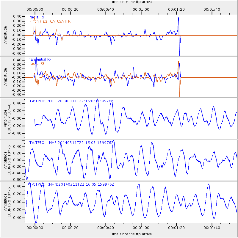
TPFO Pinon Flats, CA, USA - Earthquake Result Viewer
*The percent match for this event was below the threshold and hence no stack was calculated.
| Earthquake location: |
Bismarck Sea |
| Earthquake latitude/longitude: |
-3.1/148.6 |
| Earthquake time(UTC): |
2014/03/11 (070) 22:03:09 GMT |
| Earthquake Depth: |
7.0 km |
| Earthquake Magnitude: |
6.1 MWW, 6.1 MWC, 6.1 MWB, 6.2 MWC |
| Earthquake Catalog/Contributor: |
NEIC PDE/NEIC COMCAT |
|
| Network: |
TA USArray Transportable Network (new EarthScope stations) |
| Station: |
TPFO Pinon Flats, CA, USA |
| Lat/Lon: |
33.61 N/116.45 W |
| Elevation: |
1275 m |
|
| Distance: |
95.9 deg |
| Az: |
56.695 deg |
| Baz: |
270.187 deg |
| Ray Param: |
$rayparam |
*The percent match for this event was below the threshold and hence was not used in the summary stack. |
|
| Radial Match: |
36.37374 % |
| Radial Bump: |
394 |
| Transverse Match: |
71.5295 % |
| Transverse Bump: |
399 |
| SOD ConfigId: |
626651 |
| Insert Time: |
2014-04-21 03:52:05.933 +0000 |
| GWidth: |
2.5 |
| Max Bumps: |
400 |
| Tol: |
0.001 |
|
Signal To Noise
| Channel | StoN | STA | LTA |
| TA:TPFO: :HHZ:20140311T22:16:05.159976Z | 0.6217664 | 1.6411485E-7 | 2.6394937E-7 |
| TA:TPFO: :HHN:20140311T22:16:05.159976Z | 2.1069868 | 3.6565652E-7 | 1.7354476E-7 |
| TA:TPFO: :HHE:20140311T22:16:05.159976Z | 1.9927604 | 2.8699358E-7 | 1.440181E-7 |
| Arrivals |
| Ps | |
| PpPs | |
| PsPs/PpSs | |


