You are here: Home > Network List > UW - Pacific Northwest Regional Seismic Network Stations List
> Station PASS Maple Falls, WA, USA > Earthquake Result Viewer
PASS Maple Falls, WA, USA - Earthquake Result Viewer
| Earthquake location: |
Bismarck Sea |
| Earthquake latitude/longitude: |
-3.1/148.6 |
| Earthquake time(UTC): |
2014/03/11 (070) 22:03:09 GMT |
| Earthquake Depth: |
7.0 km |
| Earthquake Magnitude: |
6.1 MWW, 6.1 MWC, 6.1 MWB, 6.2 MWC |
| Earthquake Catalog/Contributor: |
NEIC PDE/NEIC COMCAT |
|
| Network: |
UW Pacific Northwest Regional Seismic Network |
| Station: |
PASS Maple Falls, WA, USA |
| Lat/Lon: |
49.00 N/122.09 W |
| Elevation: |
174 m |
|
| Distance: |
91.9 deg |
| Az: |
41.216 deg |
| Baz: |
267.501 deg |
| Ray Param: |
0.041542877 |
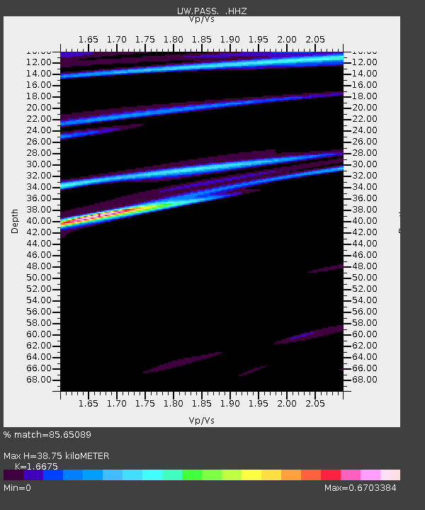
| Estimated Moho Depth: |
38.75 km |
| Estimated Crust Vp/Vs: |
1.67 |
| Assumed Crust Vp: |
6.566 km/s |
| Estimated Crust Vs: |
3.938 km/s |
| Estimated Crust Poisson's Ratio: |
0.22 |
|
| Radial Match: |
85.65089 % |
| Radial Bump: |
286 |
| Transverse Match: |
98.805786 % |
| Transverse Bump: |
63 |
| SOD ConfigId: |
626651 |
| Insert Time: |
2014-04-21 03:53:09.662 +0000 |
| GWidth: |
2.5 |
| Max Bumps: |
400 |
| Tol: |
0.001 |
|
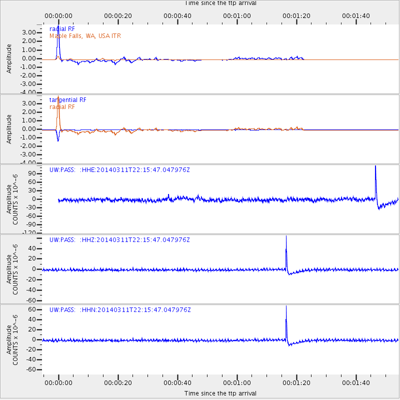
Signal To Noise
| Channel | StoN | STA | LTA |
| UW:PASS: :HHZ:20140311T22:15:47.047976Z | 1.0683872 | 1.1542453E-6 | 1.0803625E-6 |
| UW:PASS: :HHN:20140311T22:15:47.047976Z | 1.0841799 | 1.2302513E-6 | 1.1347299E-6 |
| UW:PASS: :HHE:20140311T22:15:47.047976Z | 1.315712 | 4.025889E-6 | 3.0598562E-6 |
| Arrivals |
| Ps | 4.0 SECOND |
| PpPs | 15 SECOND |
| PsPs/PpSs | 19 SECOND |


