You are here: Home > Network List > II - Global Seismograph Network (GSN - IRIS/IDA) Stations List
> Station BRVK Borovoye, Kazakhstan > Earthquake Result Viewer
BRVK Borovoye, Kazakhstan - Earthquake Result Viewer

| Earthquake location: |
Kuril Islands |
| Earthquake latitude/longitude: |
43.2/146.4 |
| Earthquake time(UTC): |
1997/07/14 (195) 16:09:35 GMT |
| Earthquake Depth: |
33 km |
| Earthquake Magnitude: |
5.9 MB, 5.8 MS, 6.1 UNKNOWN, 5.8 ME |
| Earthquake Catalog/Contributor: |
WHDF/NEIC |
|
| Network: |
II Global Seismograph Network (GSN - IRIS/IDA) |
| Station: |
BRVK Borovoye, Kazakhstan |
| Lat/Lon: |
53.06 N/70.28 E |
| Elevation: |
330 m |
|
| Distance: |
49.4 deg |
| Az: |
309.534 deg |
| Baz: |
69.011 deg |
| Ray Param: |
0.06863929 |
| Estimated Moho Depth: |
46.0 km |
| Estimated Crust Vp/Vs: |
1.72 |
| Assumed Crust Vp: |
6.552 km/s |
| Estimated Crust Vs: |
3.804 km/s |
| Estimated Crust Poisson's Ratio: |
0.25 |
|
| Radial Match: |
97.57709 % |
| Radial Bump: |
325 |
| Transverse Match: |
89.633606 % |
| Transverse Bump: |
400 |
| SOD ConfigId: |
6273 |
| Insert Time: |
2010-03-01 19:05:21.742 +0000 |
| GWidth: |
2.5 |
| Max Bumps: |
400 |
| Tol: |
0.001 |
|
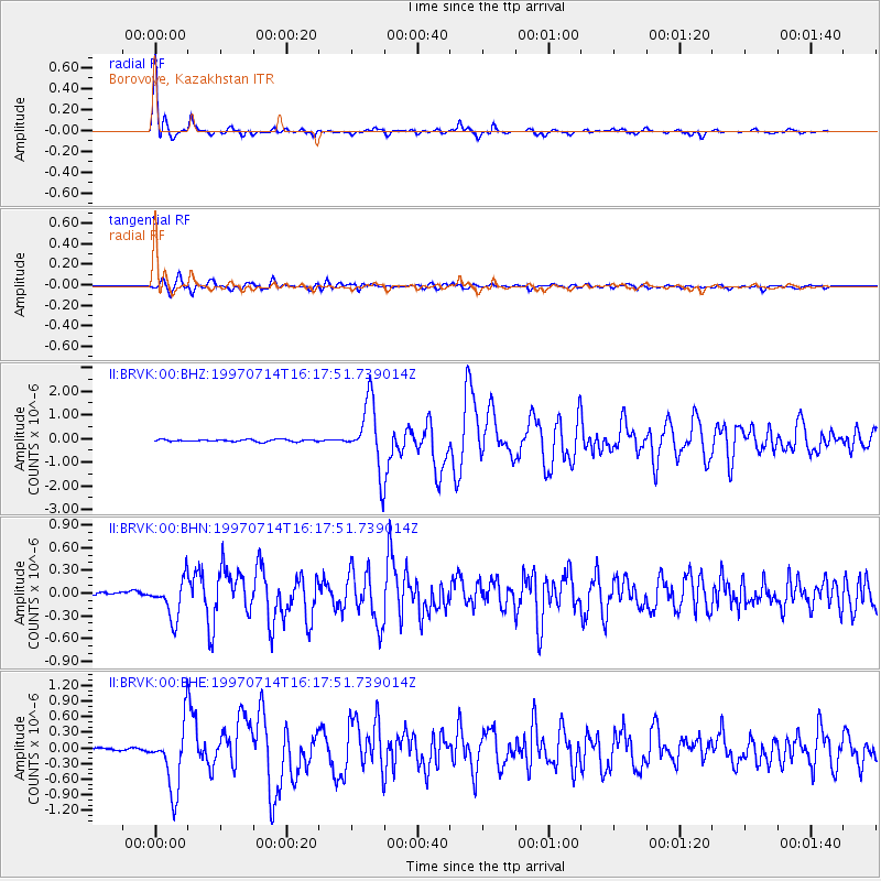
Signal To Noise
| Channel | StoN | STA | LTA |
| II:BRVK:00:BHN:19970714T16:17:51.739014Z | 9.559832 | 2.5238248E-7 | 2.6400304E-8 |
| II:BRVK:00:BHE:19970714T16:17:51.739014Z | 30.716616 | 6.399453E-7 | 2.0833847E-8 |
| II:BRVK:00:BHZ:19970714T16:17:51.739014Z | 33.17268 | 1.4069846E-6 | 4.241396E-8 |
| Arrivals |
| Ps | 5.4 SECOND |
| PpPs | 18 SECOND |
| PsPs/PpSs | 23 SECOND |


