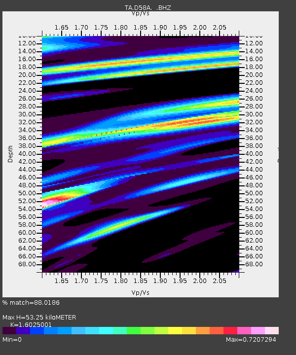
D58A Chemin du LacGrosbois, Trois-Rives, QC, CAN - Earthquake Result Viewer
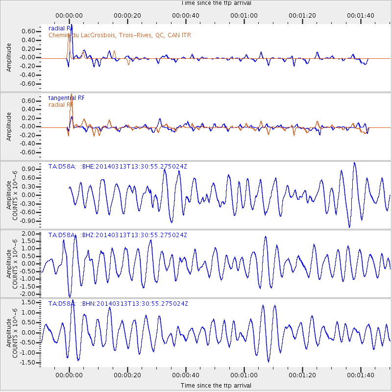
Earthquake location: Andreanof Islands, Aleutian Is.
Earthquake latitude/longitude: 51.2/-179.1
Earthquake time(UTC): 2014/03/13 (072) 13:20:59 GMT
Earthquake Depth: 26 km
Earthquake Magnitude: 5.6 MWC, 5.1 ML, 5.4 MWW, 5.4 MWB, 5.5 ML, 5.6 MWC
Earthquake Catalog/Contributor: NEIC PDE/NEIC COMCAT
Network: TA USArray Transportable Network (new EarthScope stations)
Station: D58A Chemin du LacGrosbois, Trois-Rives, QC, CAN
Lat/Lon: 47.10 N/72.88 W
Elevation: 398 m
Distance: 63.4 deg
Az: 47.187 deg
Baz: 317.515 deg
Ray Param: 0.059556823
Estimated Moho Depth: 53.25 km
Estimated Crust Vp/Vs: 1.60
Assumed Crust Vp: 6.61 km/s
Estimated Crust Vs: 4.125 km/s
Estimated Crust Poisson's Ratio: 0.18
Radial Match: 88.0186 %
Radial Bump: 400
Transverse Match: 50.915886 %
Transverse Bump: 400
SOD ConfigId: 626651
Insert Time: 2014-04-21 04:12:47.869 +0000
GWidth: 2.5
Max Bumps: 400
Tol: 0.001

Signal To Noise

ChannelStoNSTALTA
TA:D58A: :BHZ:20140313T13:30:55.275024Z3.23192051.3295378E-64.11377E-7
TA:D58A: :BHN:20140313T13:30:55.275024Z2.88313531.0080047E-63.4962102E-7
TA:D58A: :BHE:20140313T13:30:55.275024Z1.46300554.9924336E-73.41245E-7
Arrivals
Ps5.1 SECOND
PpPs20 SECOND
PsPs/PpSs25 SECOND