You are here: Home > Network List > TA - USArray Transportable Network (new EarthScope stations) Stations List
> Station N47A Urbana, IN, USA > Earthquake Result Viewer
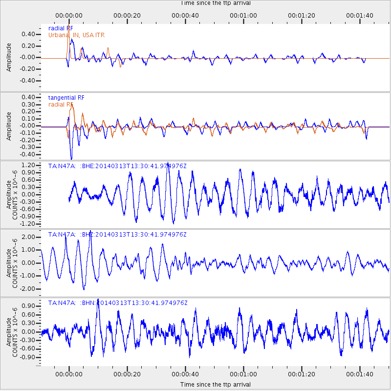
N47A Urbana, IN, USA - Earthquake Result Viewer
*The percent match for this event was below the threshold and hence no stack was calculated.
| Earthquake location: |
Andreanof Islands, Aleutian Is. |
| Earthquake latitude/longitude: |
51.2/-179.1 |
| Earthquake time(UTC): |
2014/03/13 (072) 13:20:59 GMT |
| Earthquake Depth: |
26 km |
| Earthquake Magnitude: |
5.6 MWC, 5.1 ML, 5.4 MWW, 5.4 MWB, 5.5 ML, 5.6 MWC |
| Earthquake Catalog/Contributor: |
NEIC PDE/NEIC COMCAT |
|
| Network: |
TA USArray Transportable Network (new EarthScope stations) |
| Station: |
N47A Urbana, IN, USA |
| Lat/Lon: |
40.88 N/85.69 W |
| Elevation: |
252 m |
|
| Distance: |
61.4 deg |
| Az: |
59.535 deg |
| Baz: |
314.351 deg |
| Ray Param: |
$rayparam |
*The percent match for this event was below the threshold and hence was not used in the summary stack. |
|
| Radial Match: |
73.00214 % |
| Radial Bump: |
400 |
| Transverse Match: |
71.504585 % |
| Transverse Bump: |
400 |
| SOD ConfigId: |
626651 |
| Insert Time: |
2014-04-21 04:16:07.061 +0000 |
| GWidth: |
2.5 |
| Max Bumps: |
400 |
| Tol: |
0.001 |
|
Signal To Noise
| Channel | StoN | STA | LTA |
| TA:N47A: :BHZ:20140313T13:30:41.974976Z | 1.9513036 | 1.0816268E-6 | 5.5430985E-7 |
| TA:N47A: :BHN:20140313T13:30:41.974976Z | 0.76092327 | 2.0413462E-7 | 2.682723E-7 |
| TA:N47A: :BHE:20140313T13:30:41.974976Z | 1.8611231 | 7.035806E-7 | 3.7804085E-7 |
| Arrivals |
| Ps | |
| PpPs | |
| PsPs/PpSs | |


