You are here: Home > Network List > UW - Pacific Northwest Regional Seismic Network Stations List
> Station MRBL Marblemount, WA, USA > Earthquake Result Viewer
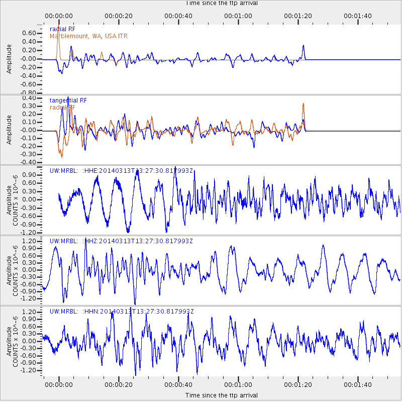
MRBL Marblemount, WA, USA - Earthquake Result Viewer
*The percent match for this event was below the threshold and hence no stack was calculated.
| Earthquake location: |
Andreanof Islands, Aleutian Is. |
| Earthquake latitude/longitude: |
51.2/-179.1 |
| Earthquake time(UTC): |
2014/03/13 (072) 13:20:59 GMT |
| Earthquake Depth: |
26 km |
| Earthquake Magnitude: |
5.6 MWC, 5.1 ML, 5.4 MWW, 5.4 MWB, 5.5 ML, 5.6 MWC |
| Earthquake Catalog/Contributor: |
NEIC PDE/NEIC COMCAT |
|
| Network: |
UW Pacific Northwest Regional Seismic Network |
| Station: |
MRBL Marblemount, WA, USA |
| Lat/Lon: |
48.52 N/121.48 W |
| Elevation: |
75 m |
|
| Distance: |
36.4 deg |
| Az: |
71.022 deg |
| Baz: |
296.533 deg |
| Ray Param: |
$rayparam |
*The percent match for this event was below the threshold and hence was not used in the summary stack. |
|
| Radial Match: |
67.53273 % |
| Radial Bump: |
400 |
| Transverse Match: |
56.559315 % |
| Transverse Bump: |
400 |
| SOD ConfigId: |
626651 |
| Insert Time: |
2014-04-21 04:21:53.769 +0000 |
| GWidth: |
2.5 |
| Max Bumps: |
400 |
| Tol: |
0.001 |
|
Signal To Noise
| Channel | StoN | STA | LTA |
| UW:MRBL: :HHZ:20140313T13:27:30.817993Z | 1.6806712 | 7.0204624E-7 | 4.1771779E-7 |
| UW:MRBL: :HHN:20140313T13:27:30.817993Z | 0.97838306 | 2.502532E-7 | 2.5578245E-7 |
| UW:MRBL: :HHE:20140313T13:27:30.817993Z | 0.96001095 | 4.8886534E-7 | 5.092289E-7 |
| Arrivals |
| Ps | |
| PpPs | |
| PsPs/PpSs | |


