You are here: Home > Network List > TA - USArray Transportable Network (new EarthScope stations) Stations List
> Station T56A Rocky Mt, VA, USA > Earthquake Result Viewer
T56A Rocky Mt, VA, USA - Earthquake Result Viewer
*The percent match for this event was below the threshold and hence no stack was calculated.
| Earthquake location: |
Peru-Ecuador Border Region |
| Earthquake latitude/longitude: |
-3.4/-80.1 |
| Earthquake time(UTC): |
2015/01/16 (016) 11:39:21 GMT |
| Earthquake Depth: |
68 km |
| Earthquake Magnitude: |
5.2 MW, 5.1 mb |
| Earthquake Catalog/Contributor: |
ISC/ISC |
|
| Network: |
TA USArray Transportable Network (new EarthScope stations) |
| Station: |
T56A Rocky Mt, VA, USA |
| Lat/Lon: |
37.03 N/80.03 W |
| Elevation: |
387 m |
|
| Distance: |
40.2 deg |
| Az: |
0.092 deg |
| Baz: |
180.115 deg |
| Ray Param: |
$rayparam |
*The percent match for this event was below the threshold and hence was not used in the summary stack. |
|
| Radial Match: |
46.414425 % |
| Radial Bump: |
400 |
| Transverse Match: |
43.31791 % |
| Transverse Bump: |
400 |
| SOD ConfigId: |
3390531 |
| Insert Time: |
2019-04-16 01:47:16.537 +0000 |
| GWidth: |
2.5 |
| Max Bumps: |
400 |
| Tol: |
0.001 |
|
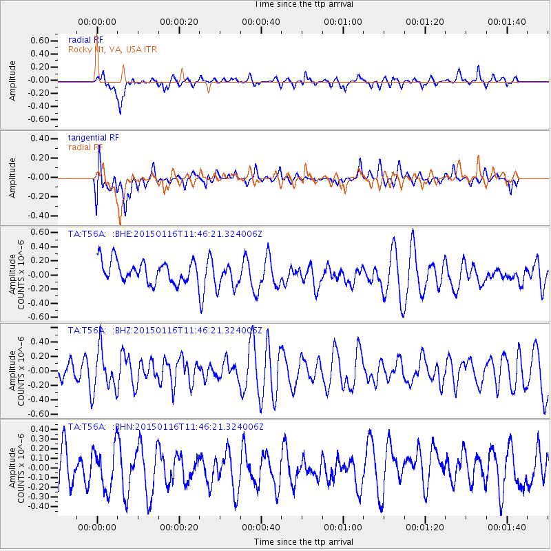
Signal To Noise
| Channel | StoN | STA | LTA |
| TA:T56A: :BHZ:20150116T11:46:21.324006Z | 1.0450574 | 2.7434675E-7 | 2.6251834E-7 |
| TA:T56A: :BHN:20150116T11:46:21.324006Z | 1.0408732 | 2.2553954E-7 | 2.16683E-7 |
| TA:T56A: :BHE:20150116T11:46:21.324006Z | 1.2188785 | 1.8430552E-7 | 1.512091E-7 |
| Arrivals |
| Ps | |
| PpPs | |
| PsPs/PpSs | |


