You are here: Home > Network List > US - United States National Seismic Network Stations List
> Station AMTX Amarillo, Texas, USA > Earthquake Result Viewer
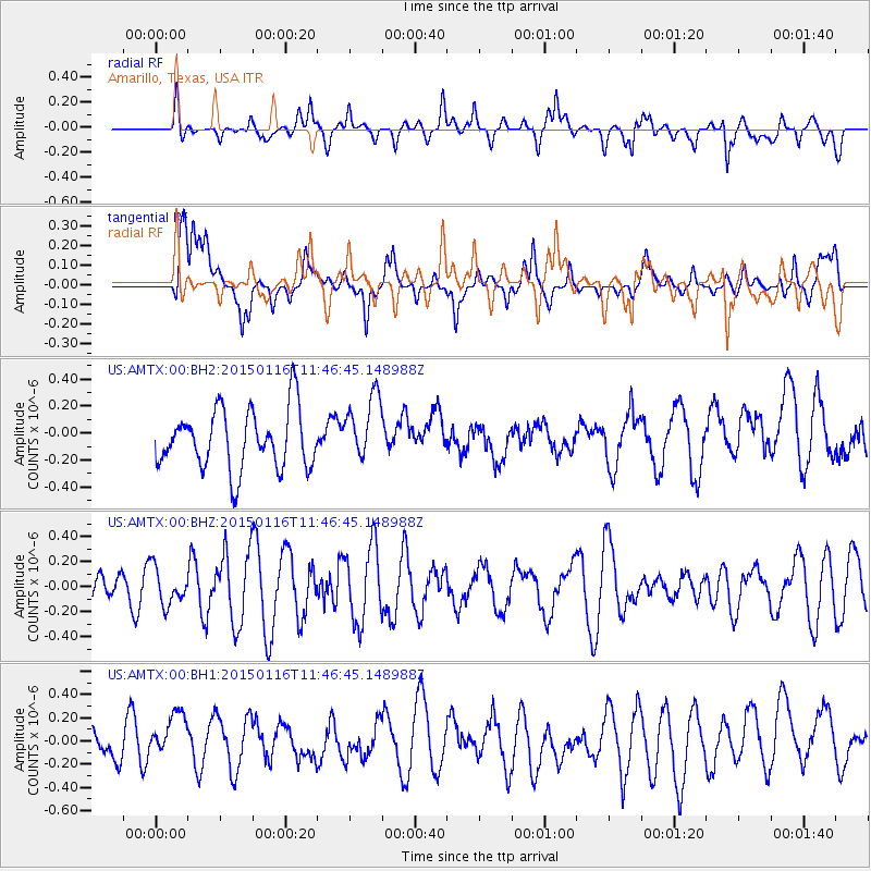
AMTX Amarillo, Texas, USA - Earthquake Result Viewer
*The percent match for this event was below the threshold and hence no stack was calculated.
| Earthquake location: |
Peru-Ecuador Border Region |
| Earthquake latitude/longitude: |
-3.4/-80.1 |
| Earthquake time(UTC): |
2015/01/16 (016) 11:39:21 GMT |
| Earthquake Depth: |
68 km |
| Earthquake Magnitude: |
5.2 MW, 5.1 mb |
| Earthquake Catalog/Contributor: |
ISC/ISC |
|
| Network: |
US United States National Seismic Network |
| Station: |
AMTX Amarillo, Texas, USA |
| Lat/Lon: |
34.53 N/101.41 W |
| Elevation: |
1010 m |
|
| Distance: |
42.7 deg |
| Az: |
333.765 deg |
| Baz: |
147.69 deg |
| Ray Param: |
$rayparam |
*The percent match for this event was below the threshold and hence was not used in the summary stack. |
|
| Radial Match: |
53.580204 % |
| Radial Bump: |
368 |
| Transverse Match: |
52.853867 % |
| Transverse Bump: |
400 |
| SOD ConfigId: |
3390531 |
| Insert Time: |
2019-04-16 01:47:42.744 +0000 |
| GWidth: |
2.5 |
| Max Bumps: |
400 |
| Tol: |
0.001 |
|
Signal To Noise
| Channel | StoN | STA | LTA |
| US:AMTX:00:BHZ:20150116T11:46:45.148988Z | 1.018013 | 1.4317337E-7 | 1.4064001E-7 |
| US:AMTX:00:BH1:20150116T11:46:45.148988Z | 0.65256196 | 1.933881E-7 | 2.9635208E-7 |
| US:AMTX:00:BH2:20150116T11:46:45.148988Z | 0.6796133 | 1.469596E-7 | 2.1624001E-7 |
| Arrivals |
| Ps | |
| PpPs | |
| PsPs/PpSs | |


