You are here: Home > Network List > G - GEOSCOPE Stations List
> Station ATD Arta Cave - Arta, Republic of Djibouti > Earthquake Result Viewer
ATD Arta Cave - Arta, Republic of Djibouti - Earthquake Result Viewer
| Earthquake location: |
Kyushu, Japan |
| Earthquake latitude/longitude: |
33.7/131.8 |
| Earthquake time(UTC): |
2014/03/13 (072) 17:06:50 GMT |
| Earthquake Depth: |
79 km |
| Earthquake Magnitude: |
6.3 MWW, 6.3 MWB, 6.3 MWC |
| Earthquake Catalog/Contributor: |
NEIC PDE/NEIC COMCAT |
|
| Network: |
G GEOSCOPE |
| Station: |
ATD Arta Cave - Arta, Republic of Djibouti |
| Lat/Lon: |
11.53 N/42.85 E |
| Elevation: |
610 m |
|
| Distance: |
82.9 deg |
| Az: |
279.043 deg |
| Baz: |
57.161 deg |
| Ray Param: |
0.046430327 |
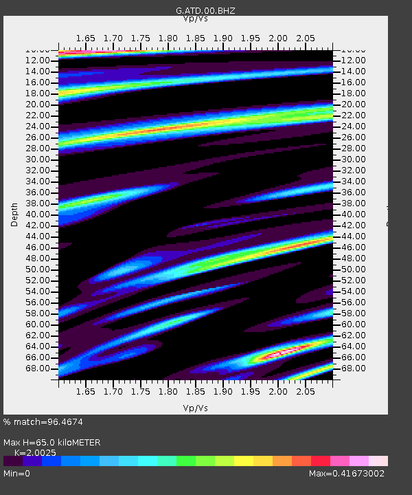
| Estimated Moho Depth: |
65.0 km |
| Estimated Crust Vp/Vs: |
2.00 |
| Assumed Crust Vp: |
6.375 km/s |
| Estimated Crust Vs: |
3.184 km/s |
| Estimated Crust Poisson's Ratio: |
0.33 |
|
| Radial Match: |
96.4674 % |
| Radial Bump: |
345 |
| Transverse Match: |
83.443954 % |
| Transverse Bump: |
400 |
| SOD ConfigId: |
626651 |
| Insert Time: |
2014-04-21 04:32:53.435 +0000 |
| GWidth: |
2.5 |
| Max Bumps: |
400 |
| Tol: |
0.001 |
|
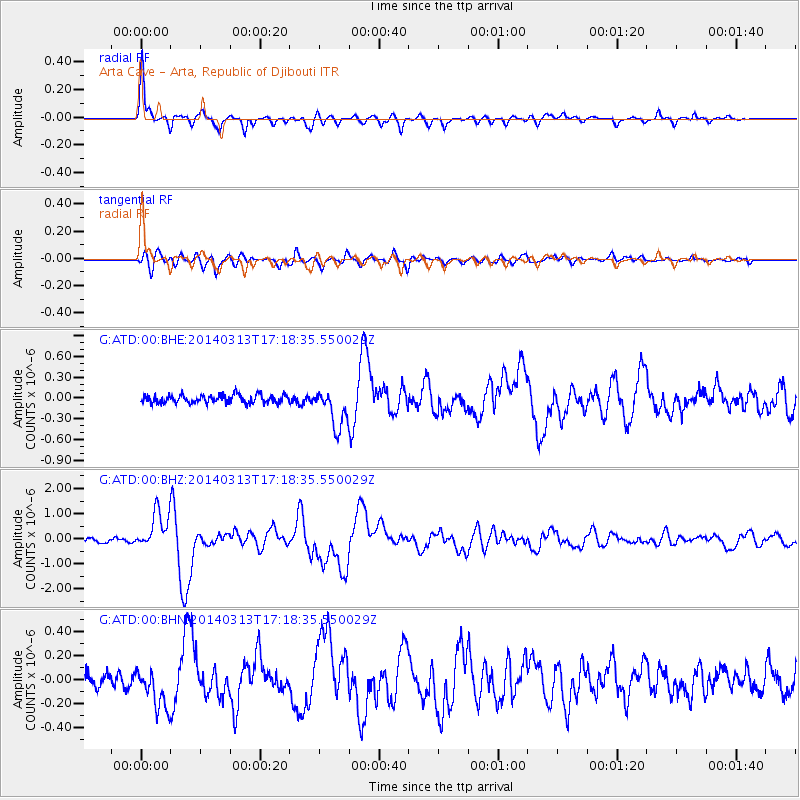
Signal To Noise
| Channel | StoN | STA | LTA |
| G:ATD:00:BHZ:20140313T17:18:35.550029Z | 11.217121 | 7.758061E-7 | 6.9162674E-8 |
| G:ATD:00:BHN:20140313T17:18:35.550029Z | 2.7868867 | 1.6494819E-7 | 5.918726E-8 |
| G:ATD:00:BHE:20140313T17:18:35.550029Z | 4.723705 | 2.7973695E-7 | 5.9219822E-8 |
| Arrivals |
| Ps | 10 SECOND |
| PpPs | 30 SECOND |
| PsPs/PpSs | 40 SECOND |


