You are here: Home > Network List > IU - Global Seismograph Network (GSN - IRIS/USGS) Stations List
> Station GNI Garni, Armenia > Earthquake Result Viewer
GNI Garni, Armenia - Earthquake Result Viewer
| Earthquake location: |
Kyushu, Japan |
| Earthquake latitude/longitude: |
33.7/131.8 |
| Earthquake time(UTC): |
2014/03/13 (072) 17:06:50 GMT |
| Earthquake Depth: |
79 km |
| Earthquake Magnitude: |
6.3 MWW, 6.3 MWB, 6.3 MWC |
| Earthquake Catalog/Contributor: |
NEIC PDE/NEIC COMCAT |
|
| Network: |
IU Global Seismograph Network (GSN - IRIS/USGS) |
| Station: |
GNI Garni, Armenia |
| Lat/Lon: |
40.15 N/44.74 E |
| Elevation: |
1609 m |
|
| Distance: |
67.2 deg |
| Az: |
303.878 deg |
| Baz: |
64.573 deg |
| Ray Param: |
0.056901284 |
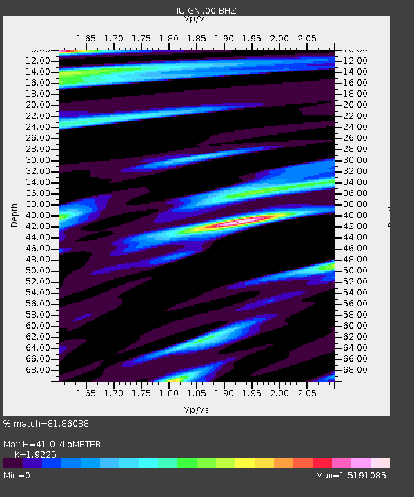
| Estimated Moho Depth: |
41.0 km |
| Estimated Crust Vp/Vs: |
1.92 |
| Assumed Crust Vp: |
6.291 km/s |
| Estimated Crust Vs: |
3.272 km/s |
| Estimated Crust Poisson's Ratio: |
0.31 |
|
| Radial Match: |
81.86088 % |
| Radial Bump: |
400 |
| Transverse Match: |
69.72659 % |
| Transverse Bump: |
400 |
| SOD ConfigId: |
626651 |
| Insert Time: |
2014-04-21 04:37:34.291 +0000 |
| GWidth: |
2.5 |
| Max Bumps: |
400 |
| Tol: |
0.001 |
|
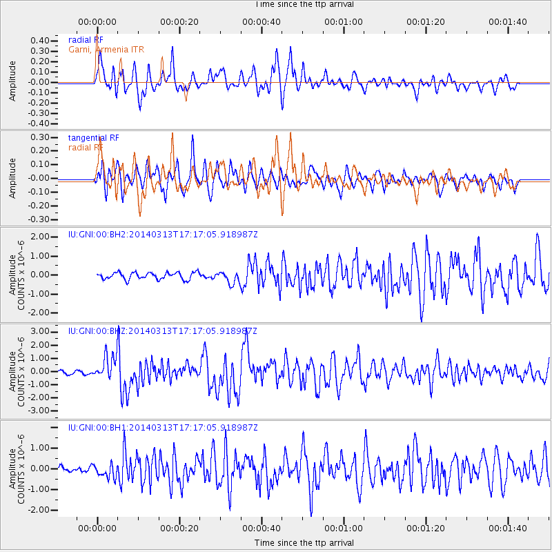
Signal To Noise
| Channel | StoN | STA | LTA |
| IU:GNI:00:BHZ:20140313T17:17:05.918987Z | 8.3242035 | 9.761087E-7 | 1.1726151E-7 |
| IU:GNI:00:BH1:20140313T17:17:05.918987Z | 3.0031521 | 3.1386224E-7 | 1.0451093E-7 |
| IU:GNI:00:BH2:20140313T17:17:05.918987Z | 1.8100562 | 3.276079E-7 | 1.8099321E-7 |
| Arrivals |
| Ps | 6.2 SECOND |
| PpPs | 18 SECOND |
| PsPs/PpSs | 25 SECOND |


