You are here: Home > Network List > TJ - Tajikistan National Seismic Network Stations List
> Station IGRN Igron, Tajikistan > Earthquake Result Viewer
IGRN Igron, Tajikistan - Earthquake Result Viewer
| Earthquake location: |
Kyushu, Japan |
| Earthquake latitude/longitude: |
33.7/131.8 |
| Earthquake time(UTC): |
2014/03/13 (072) 17:06:50 GMT |
| Earthquake Depth: |
79 km |
| Earthquake Magnitude: |
6.3 MWW, 6.3 MWB, 6.3 MWC |
| Earthquake Catalog/Contributor: |
NEIC PDE/NEIC COMCAT |
|
| Network: |
TJ Tajikistan National Seismic Network |
| Station: |
IGRN Igron, Tajikistan |
| Lat/Lon: |
38.22 N/69.33 E |
| Elevation: |
1284 m |
|
| Distance: |
50.0 deg |
| Az: |
294.129 deg |
| Baz: |
75.043 deg |
| Ray Param: |
0.06813302 |
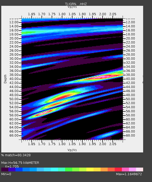
| Estimated Moho Depth: |
56.75 km |
| Estimated Crust Vp/Vs: |
1.71 |
| Assumed Crust Vp: |
6.483 km/s |
| Estimated Crust Vs: |
3.802 km/s |
| Estimated Crust Poisson's Ratio: |
0.24 |
|
| Radial Match: |
80.3428 % |
| Radial Bump: |
400 |
| Transverse Match: |
78.14387 % |
| Transverse Bump: |
400 |
| SOD ConfigId: |
626651 |
| Insert Time: |
2014-04-21 04:46:23.928 +0000 |
| GWidth: |
2.5 |
| Max Bumps: |
400 |
| Tol: |
0.001 |
|

Signal To Noise
| Channel | StoN | STA | LTA |
| TJ:IGRN: :HHZ:20140313T17:15:06.169994Z | 14.271143 | 2.6670655E-6 | 1.8688522E-7 |
| TJ:IGRN: :HHN:20140313T17:15:06.169994Z | 2.7943606 | 4.4628507E-8 | 1.5970919E-8 |
| TJ:IGRN: :HHE:20140313T17:15:06.169994Z | 6.4779406 | 1.1298233E-6 | 1.7441089E-7 |
| Arrivals |
| Ps | 6.6 SECOND |
| PpPs | 22 SECOND |
| PsPs/PpSs | 29 SECOND |


