You are here: Home > Network List > US - United States National Seismic Network Stations List
> Station DGMT Dagmar, Montana, USA > Earthquake Result Viewer
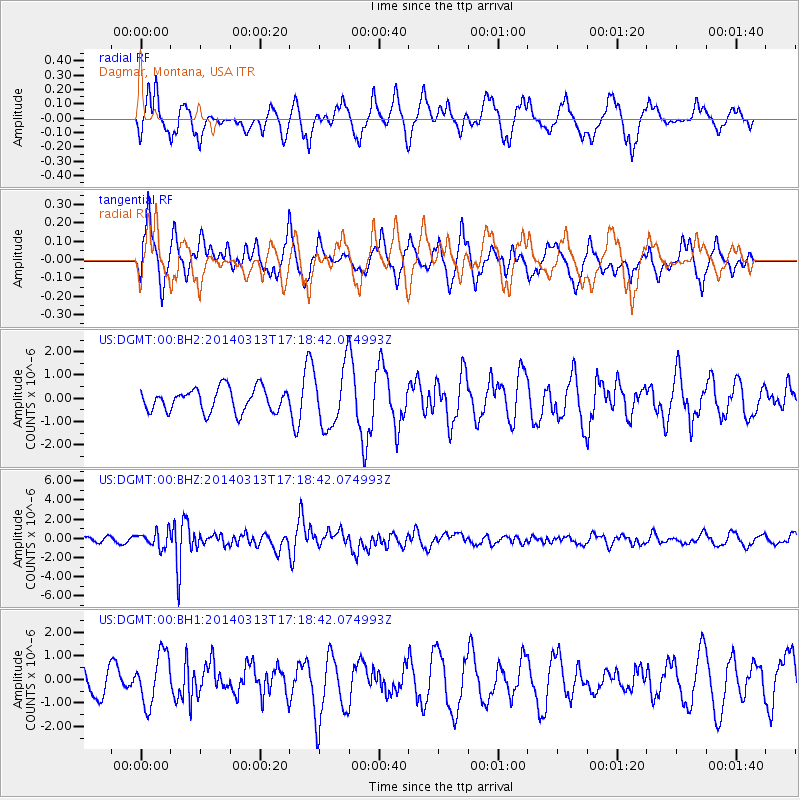
DGMT Dagmar, Montana, USA - Earthquake Result Viewer
*The percent match for this event was below the threshold and hence no stack was calculated.
| Earthquake location: |
Kyushu, Japan |
| Earthquake latitude/longitude: |
33.7/131.8 |
| Earthquake time(UTC): |
2014/03/13 (072) 17:06:50 GMT |
| Earthquake Depth: |
79 km |
| Earthquake Magnitude: |
6.3 MWW, 6.3 MWB, 6.3 MWC |
| Earthquake Catalog/Contributor: |
NEIC PDE/NEIC COMCAT |
|
| Network: |
US United States National Seismic Network |
| Station: |
DGMT Dagmar, Montana, USA |
| Lat/Lon: |
48.47 N/104.20 W |
| Elevation: |
0.0 m |
|
| Distance: |
84.2 deg |
| Az: |
33.693 deg |
| Baz: |
315.969 deg |
| Ray Param: |
$rayparam |
*The percent match for this event was below the threshold and hence was not used in the summary stack. |
|
| Radial Match: |
54.814323 % |
| Radial Bump: |
392 |
| Transverse Match: |
51.632305 % |
| Transverse Bump: |
400 |
| SOD ConfigId: |
626651 |
| Insert Time: |
2014-04-21 04:46:45.202 +0000 |
| GWidth: |
2.5 |
| Max Bumps: |
400 |
| Tol: |
0.001 |
|
Signal To Noise
| Channel | StoN | STA | LTA |
| US:DGMT:00:BHZ:20140313T17:18:42.074993Z | 2.130396 | 8.1272873E-7 | 3.8149187E-7 |
| US:DGMT:00:BH1:20140313T17:18:42.074993Z | 1.8578445 | 1.0817317E-6 | 5.8225095E-7 |
| US:DGMT:00:BH2:20140313T17:18:42.074993Z | 2.552636 | 1.2727569E-6 | 4.9860495E-7 |
| Arrivals |
| Ps | |
| PpPs | |
| PsPs/PpSs | |


