You are here: Home > Network List > GH - Ghana Digital Seismic Network Stations List
> Station KLEF Ho, Ghana > Earthquake Result Viewer
KLEF Ho, Ghana - Earthquake Result Viewer
| Earthquake location: |
Near Coast Of Peru |
| Earthquake latitude/longitude: |
-14.1/-76.3 |
| Earthquake time(UTC): |
2014/03/15 (074) 08:59:21 GMT |
| Earthquake Depth: |
20 km |
| Earthquake Magnitude: |
6.1 MWW, 6.0 MWB, 6.2 MWC |
| Earthquake Catalog/Contributor: |
NEIC PDE/NEIC COMCAT |
|
| Network: |
GH Ghana Digital Seismic Network |
| Station: |
KLEF Ho, Ghana |
| Lat/Lon: |
6.61 N/0.44 E |
| Elevation: |
313 m |
|
| Distance: |
78.9 deg |
| Az: |
80.252 deg |
| Baz: |
254.277 deg |
| Ray Param: |
0.049338587 |
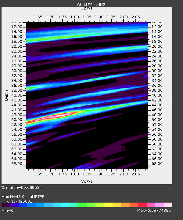
| Estimated Moho Depth: |
48.0 km |
| Estimated Crust Vp/Vs: |
1.74 |
| Assumed Crust Vp: |
6.612 km/s |
| Estimated Crust Vs: |
3.794 km/s |
| Estimated Crust Poisson's Ratio: |
0.25 |
|
| Radial Match: |
90.069534 % |
| Radial Bump: |
400 |
| Transverse Match: |
77.226456 % |
| Transverse Bump: |
400 |
| SOD ConfigId: |
626651 |
| Insert Time: |
2014-04-21 05:06:49.722 +0000 |
| GWidth: |
2.5 |
| Max Bumps: |
400 |
| Tol: |
0.001 |
|

Signal To Noise
| Channel | StoN | STA | LTA |
| GH:KLEF: :HHZ:20140315T09:10:52.089978Z | 19.571817 | 1.4932191E-6 | 7.629435E-8 |
| GH:KLEF: :HHN:20140315T09:10:52.089978Z | 1.2269897 | 1.2518194E-7 | 1.0202363E-7 |
| GH:KLEF: :HHE:20140315T09:10:52.089978Z | 6.894868 | 4.8544547E-7 | 7.040678E-8 |
| Arrivals |
| Ps | 5.6 SECOND |
| PpPs | 19 SECOND |
| PsPs/PpSs | 25 SECOND |


