You are here: Home > Network List > GH - Ghana Digital Seismic Network Stations List
> Station WEIJ Weija Dam, Ghana > Earthquake Result Viewer
WEIJ Weija Dam, Ghana - Earthquake Result Viewer
| Earthquake location: |
Near Coast Of Peru |
| Earthquake latitude/longitude: |
-14.1/-76.3 |
| Earthquake time(UTC): |
2014/03/15 (074) 08:59:21 GMT |
| Earthquake Depth: |
20 km |
| Earthquake Magnitude: |
6.1 MWW, 6.0 MWB, 6.2 MWC |
| Earthquake Catalog/Contributor: |
NEIC PDE/NEIC COMCAT |
|
| Network: |
GH Ghana Digital Seismic Network |
| Station: |
WEIJ Weija Dam, Ghana |
| Lat/Lon: |
5.59 N/0.33 W |
| Elevation: |
203 m |
|
| Distance: |
77.8 deg |
| Az: |
81.041 deg |
| Baz: |
254.355 deg |
| Ray Param: |
0.05002921 |
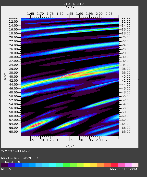
| Estimated Moho Depth: |
39.75 km |
| Estimated Crust Vp/Vs: |
1.81 |
| Assumed Crust Vp: |
6.472 km/s |
| Estimated Crust Vs: |
3.571 km/s |
| Estimated Crust Poisson's Ratio: |
0.28 |
|
| Radial Match: |
88.64703 % |
| Radial Bump: |
400 |
| Transverse Match: |
79.663414 % |
| Transverse Bump: |
383 |
| SOD ConfigId: |
626651 |
| Insert Time: |
2014-04-21 05:06:56.858 +0000 |
| GWidth: |
2.5 |
| Max Bumps: |
400 |
| Tol: |
0.001 |
|

Signal To Noise
| Channel | StoN | STA | LTA |
| GH:WEIJ: :HHZ:20140315T09:10:46.490002Z | 17.718718 | 1.5128015E-6 | 8.537873E-8 |
| GH:WEIJ: :HHN:20140315T09:10:46.490002Z | 2.2921996 | 1.6754679E-7 | 7.309433E-8 |
| GH:WEIJ: :HHE:20140315T09:10:46.490002Z | 5.1602116 | 4.3700433E-7 | 8.4687294E-8 |
| Arrivals |
| Ps | 5.1 SECOND |
| PpPs | 17 SECOND |
| PsPs/PpSs | 22 SECOND |


