You are here: Home > Network List > CI - Caltech Regional Seismic Network Stations List
> Station CIA CIA, Avalon Catalina Island, CA, USA > Earthquake Result Viewer
CIA CIA, Avalon Catalina Island, CA, USA - Earthquake Result Viewer

| Earthquake location: |
Southern Bolivia |
| Earthquake latitude/longitude: |
-20.9/-67.3 |
| Earthquake time(UTC): |
1999/09/15 (258) 03:01:24 GMT |
| Earthquake Depth: |
218 km |
| Earthquake Magnitude: |
6.0 MB, 6.4 MW, 6.4 MW |
| Earthquake Catalog/Contributor: |
WHDF/NEIC |
|
| Network: |
CI Caltech Regional Seismic Network |
| Station: |
CIA CIA, Avalon Catalina Island, CA, USA |
| Lat/Lon: |
33.40 N/118.41 W |
| Elevation: |
467 m |
|
| Distance: |
72.8 deg |
| Az: |
317.005 deg |
| Baz: |
130.356 deg |
| Ray Param: |
0.052843653 |
| Estimated Moho Depth: |
23.75 km |
| Estimated Crust Vp/Vs: |
1.60 |
| Assumed Crust Vp: |
6.048 km/s |
| Estimated Crust Vs: |
3.78 km/s |
| Estimated Crust Poisson's Ratio: |
0.18 |
|
| Radial Match: |
90.18831 % |
| Radial Bump: |
350 |
| Transverse Match: |
89.88865 % |
| Transverse Bump: |
400 |
| SOD ConfigId: |
3787 |
| Insert Time: |
2010-02-25 20:58:21.542 +0000 |
| GWidth: |
2.5 |
| Max Bumps: |
400 |
| Tol: |
0.001 |
|
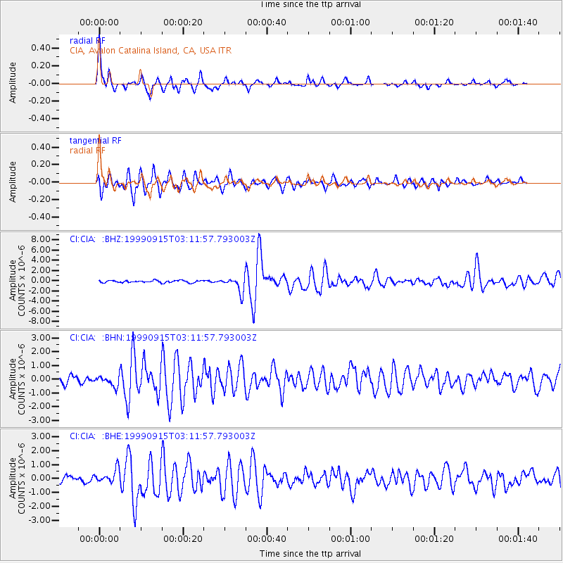
Signal To Noise
| Channel | StoN | STA | LTA |
| CI:CIA: :BHN:19990915T03:11:57.793003Z | 1.8192805 | 3.803289E-7 | 2.0905458E-7 |
| CI:CIA: :BHE:19990915T03:11:57.793003Z | 2.7249289 | 5.1427776E-7 | 1.8873071E-7 |
| CI:CIA: :BHZ:19990915T03:11:57.793003Z | 7.354537 | 1.5120714E-6 | 2.0559709E-7 |
| Arrivals |
| Ps | 2.4 SECOND |
| PpPs | 9.9 SECOND |
| PsPs/PpSs | 12 SECOND |


