You are here: Home > Network List > CI - Caltech Regional Seismic Network Stations List
> Station MPP McPhearson Peak > Earthquake Result Viewer
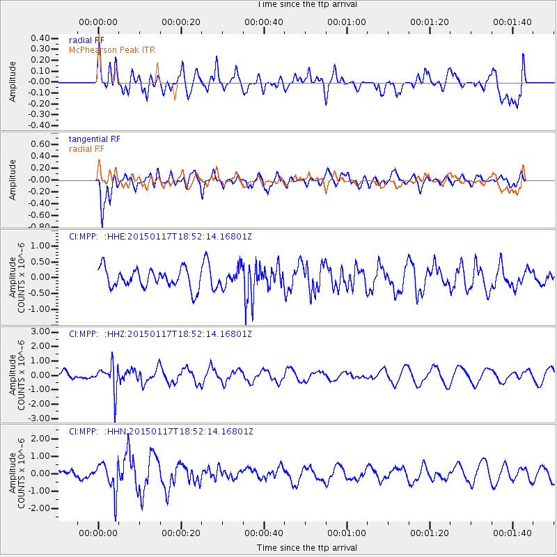
MPP McPhearson Peak - Earthquake Result Viewer
*The percent match for this event was below the threshold and hence no stack was calculated.
| Earthquake location: |
Salta Province, Argentina |
| Earthquake latitude/longitude: |
-22.2/-63.1 |
| Earthquake time(UTC): |
2015/01/17 (017) 18:41:42 GMT |
| Earthquake Depth: |
557 km |
| Earthquake Magnitude: |
5.6 MWW, 5.6 MWB |
| Earthquake Catalog/Contributor: |
NEIC PDE/NEIC COMCAT |
|
| Network: |
CI Caltech Regional Seismic Network |
| Station: |
MPP McPhearson Peak |
| Lat/Lon: |
34.89 N/119.81 W |
| Elevation: |
1739 m |
|
| Distance: |
78.2 deg |
| Az: |
315.442 deg |
| Baz: |
127.742 deg |
| Ray Param: |
$rayparam |
*The percent match for this event was below the threshold and hence was not used in the summary stack. |
|
| Radial Match: |
38.072147 % |
| Radial Bump: |
400 |
| Transverse Match: |
79.199005 % |
| Transverse Bump: |
400 |
| SOD ConfigId: |
3390531 |
| Insert Time: |
2019-04-16 02:02:32.662 +0000 |
| GWidth: |
2.5 |
| Max Bumps: |
400 |
| Tol: |
0.001 |
|
Signal To Noise
| Channel | StoN | STA | LTA |
| CI:MPP: :HHZ:20150117T18:52:14.16801Z | 2.96119 | 9.568998E-7 | 3.2314705E-7 |
| CI:MPP: :HHN:20150117T18:52:14.16801Z | 3.8333907 | 8.8958205E-7 | 2.3206142E-7 |
| CI:MPP: :HHE:20150117T18:52:14.16801Z | 0.9235241 | 2.747295E-7 | 2.9747952E-7 |
| Arrivals |
| Ps | |
| PpPs | |
| PsPs/PpSs | |


