You are here: Home > Network List > NM - Cooperative New Madrid Seismic Network Stations List
> Station FFIL Fairfield, IL > Earthquake Result Viewer
FFIL Fairfield, IL - Earthquake Result Viewer
| Earthquake location: |
Near Coast Of Peru |
| Earthquake latitude/longitude: |
-14.1/-76.3 |
| Earthquake time(UTC): |
2014/03/15 (074) 08:59:21 GMT |
| Earthquake Depth: |
20 km |
| Earthquake Magnitude: |
6.1 MWW, 6.0 MWB, 6.2 MWC |
| Earthquake Catalog/Contributor: |
NEIC PDE/NEIC COMCAT |
|
| Network: |
NM Cooperative New Madrid Seismic Network |
| Station: |
FFIL Fairfield, IL |
| Lat/Lon: |
38.38 N/88.39 W |
| Elevation: |
446 m |
|
| Distance: |
53.4 deg |
| Az: |
348.179 deg |
| Baz: |
165.351 deg |
| Ray Param: |
0.06609072 |
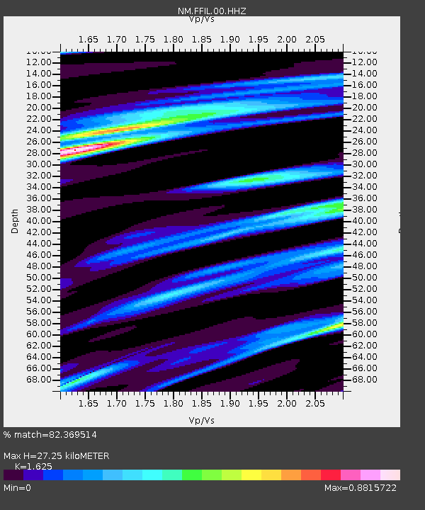
| Estimated Moho Depth: |
27.25 km |
| Estimated Crust Vp/Vs: |
1.62 |
| Assumed Crust Vp: |
6.444 km/s |
| Estimated Crust Vs: |
3.965 km/s |
| Estimated Crust Poisson's Ratio: |
0.20 |
|
| Radial Match: |
82.369514 % |
| Radial Bump: |
318 |
| Transverse Match: |
61.672977 % |
| Transverse Bump: |
399 |
| SOD ConfigId: |
626651 |
| Insert Time: |
2014-04-21 05:14:57.421 +0000 |
| GWidth: |
2.5 |
| Max Bumps: |
400 |
| Tol: |
0.001 |
|

Signal To Noise
| Channel | StoN | STA | LTA |
| NM:FFIL:00:HHZ:20140315T09:08:09.188977Z | 4.52353 | 1.2876114E-6 | 2.8464748E-7 |
| NM:FFIL:00:HHN:20140315T09:08:09.188977Z | 2.3775234 | 4.865997E-7 | 2.046666E-7 |
| NM:FFIL:00:HHE:20140315T09:08:09.188977Z | 1.0421684 | 1.5614027E-7 | 1.4982251E-7 |
| Arrivals |
| Ps | 2.8 SECOND |
| PpPs | 10 SECOND |
| PsPs/PpSs | 13 SECOND |


