You are here: Home > Network List > PB - Plate Boundary Observatory Borehole Seismic Network Stations List
> Station B081 keenwi081bcs2006, Anza, CA, USA > Earthquake Result Viewer
B081 keenwi081bcs2006, Anza, CA, USA - Earthquake Result Viewer
| Earthquake location: |
Near Coast Of Peru |
| Earthquake latitude/longitude: |
-14.1/-76.3 |
| Earthquake time(UTC): |
2014/03/15 (074) 08:59:21 GMT |
| Earthquake Depth: |
20 km |
| Earthquake Magnitude: |
6.1 MWW, 6.0 MWB, 6.2 MWC |
| Earthquake Catalog/Contributor: |
NEIC PDE/NEIC COMCAT |
|
| Network: |
PB Plate Boundary Observatory Borehole Seismic Network |
| Station: |
B081 keenwi081bcs2006, Anza, CA, USA |
| Lat/Lon: |
33.71 N/116.71 W |
| Elevation: |
1467 m |
|
| Distance: |
61.2 deg |
| Az: |
321.922 deg |
| Baz: |
134.12 deg |
| Ray Param: |
0.061024133 |
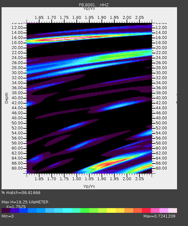
| Estimated Moho Depth: |
16.25 km |
| Estimated Crust Vp/Vs: |
1.75 |
| Assumed Crust Vp: |
6.264 km/s |
| Estimated Crust Vs: |
3.574 km/s |
| Estimated Crust Poisson's Ratio: |
0.26 |
|
| Radial Match: |
86.61666 % |
| Radial Bump: |
400 |
| Transverse Match: |
81.65744 % |
| Transverse Bump: |
400 |
| SOD ConfigId: |
626651 |
| Insert Time: |
2014-04-21 05:16:46.910 +0000 |
| GWidth: |
2.5 |
| Max Bumps: |
400 |
| Tol: |
0.001 |
|

Signal To Noise
| Channel | StoN | STA | LTA |
| PB:B081: :HHZ:20140315T09:09:03.849011Z | 6.6645956 | 1.3603662E-8 | 2.0411834E-9 |
| PB:B081: :HH1:20140315T09:09:03.849011Z | 0.8563647 | 8.338713E-10 | 9.737339E-10 |
| PB:B081: :HH2:20140315T09:09:03.849011Z | 3.1954086 | 5.382697E-9 | 1.6845099E-9 |
| Arrivals |
| Ps | 2.0 SECOND |
| PpPs | 6.8 SECOND |
| PsPs/PpSs | 8.9 SECOND |


