You are here: Home > Network List > TA - USArray Transportable Network (new EarthScope stations) Stations List
> Station H63A New Sharon, ME, USA > Earthquake Result Viewer
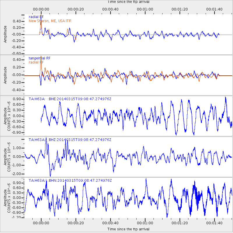
H63A New Sharon, ME, USA - Earthquake Result Viewer
*The percent match for this event was below the threshold and hence no stack was calculated.
| Earthquake location: |
Near Coast Of Peru |
| Earthquake latitude/longitude: |
-14.1/-76.3 |
| Earthquake time(UTC): |
2014/03/15 (074) 08:59:21 GMT |
| Earthquake Depth: |
20 km |
| Earthquake Magnitude: |
6.1 MWW, 6.0 MWB, 6.2 MWC |
| Earthquake Catalog/Contributor: |
NEIC PDE/NEIC COMCAT |
|
| Network: |
TA USArray Transportable Network (new EarthScope stations) |
| Station: |
H63A New Sharon, ME, USA |
| Lat/Lon: |
44.66 N/70.04 W |
| Elevation: |
109 m |
|
| Distance: |
58.8 deg |
| Az: |
5.233 deg |
| Baz: |
187.124 deg |
| Ray Param: |
$rayparam |
*The percent match for this event was below the threshold and hence was not used in the summary stack. |
|
| Radial Match: |
70.82518 % |
| Radial Bump: |
400 |
| Transverse Match: |
56.825962 % |
| Transverse Bump: |
400 |
| SOD ConfigId: |
626651 |
| Insert Time: |
2014-04-21 05:22:43.567 +0000 |
| GWidth: |
2.5 |
| Max Bumps: |
400 |
| Tol: |
0.001 |
|
Signal To Noise
| Channel | StoN | STA | LTA |
| TA:H63A: :BHZ:20140315T09:08:47.274976Z | 2.4137435 | 9.3405293E-7 | 3.8697274E-7 |
| TA:H63A: :BHN:20140315T09:08:47.274976Z | 1.2290622 | 4.2003208E-7 | 3.4175005E-7 |
| TA:H63A: :BHE:20140315T09:08:47.274976Z | 0.70992184 | 2.4464055E-7 | 3.4460209E-7 |
| Arrivals |
| Ps | |
| PpPs | |
| PsPs/PpSs | |


