You are here: Home > Network List > TA - USArray Transportable Network (new EarthScope stations) Stations List
> Station L48A N Adams, MI, USA > Earthquake Result Viewer
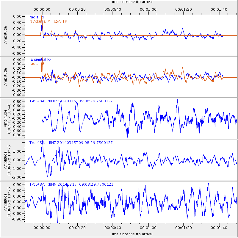
L48A N Adams, MI, USA - Earthquake Result Viewer
*The percent match for this event was below the threshold and hence no stack was calculated.
| Earthquake location: |
Near Coast Of Peru |
| Earthquake latitude/longitude: |
-14.1/-76.3 |
| Earthquake time(UTC): |
2014/03/15 (074) 08:59:21 GMT |
| Earthquake Depth: |
20 km |
| Earthquake Magnitude: |
6.1 MWW, 6.0 MWB, 6.2 MWC |
| Earthquake Catalog/Contributor: |
NEIC PDE/NEIC COMCAT |
|
| Network: |
TA USArray Transportable Network (new EarthScope stations) |
| Station: |
L48A N Adams, MI, USA |
| Lat/Lon: |
41.94 N/84.43 W |
| Elevation: |
369 m |
|
| Distance: |
56.3 deg |
| Az: |
352.716 deg |
| Baz: |
170.509 deg |
| Ray Param: |
$rayparam |
*The percent match for this event was below the threshold and hence was not used in the summary stack. |
|
| Radial Match: |
69.97409 % |
| Radial Bump: |
400 |
| Transverse Match: |
55.31693 % |
| Transverse Bump: |
400 |
| SOD ConfigId: |
626651 |
| Insert Time: |
2014-04-21 05:25:21.126 +0000 |
| GWidth: |
2.5 |
| Max Bumps: |
400 |
| Tol: |
0.001 |
|
Signal To Noise
| Channel | StoN | STA | LTA |
| TA:L48A: :BHZ:20140315T09:08:29.750012Z | 3.4075089 | 1.1798995E-6 | 3.4626456E-7 |
| TA:L48A: :BHN:20140315T09:08:29.750012Z | 2.1365857 | 4.3755975E-7 | 2.047939E-7 |
| TA:L48A: :BHE:20140315T09:08:29.750012Z | 0.4056251 | 1.5807295E-7 | 3.8970208E-7 |
| Arrivals |
| Ps | |
| PpPs | |
| PsPs/PpSs | |


