You are here: Home > Network List > TA - USArray Transportable Network (new EarthScope stations) Stations List
> Station N50A Nevada, OH, USA > Earthquake Result Viewer
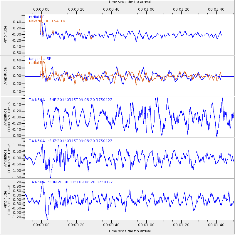
N50A Nevada, OH, USA - Earthquake Result Viewer
*The percent match for this event was below the threshold and hence no stack was calculated.
| Earthquake location: |
Near Coast Of Peru |
| Earthquake latitude/longitude: |
-14.1/-76.3 |
| Earthquake time(UTC): |
2014/03/15 (074) 08:59:21 GMT |
| Earthquake Depth: |
20 km |
| Earthquake Magnitude: |
6.1 MWW, 6.0 MWB, 6.2 MWC |
| Earthquake Catalog/Contributor: |
NEIC PDE/NEIC COMCAT |
|
| Network: |
TA USArray Transportable Network (new EarthScope stations) |
| Station: |
N50A Nevada, OH, USA |
| Lat/Lon: |
40.77 N/83.15 W |
| Elevation: |
277 m |
|
| Distance: |
55.0 deg |
| Az: |
353.657 deg |
| Baz: |
171.886 deg |
| Ray Param: |
$rayparam |
*The percent match for this event was below the threshold and hence was not used in the summary stack. |
|
| Radial Match: |
52.153435 % |
| Radial Bump: |
400 |
| Transverse Match: |
54.57944 % |
| Transverse Bump: |
400 |
| SOD ConfigId: |
626651 |
| Insert Time: |
2014-04-21 05:27:04.680 +0000 |
| GWidth: |
2.5 |
| Max Bumps: |
400 |
| Tol: |
0.001 |
|
Signal To Noise
| Channel | StoN | STA | LTA |
| TA:N50A: :BHZ:20140315T09:08:20.375012Z | 2.555467 | 6.0355677E-7 | 2.3618259E-7 |
| TA:N50A: :BHN:20140315T09:08:20.375012Z | 2.841027 | 8.034887E-7 | 2.828163E-7 |
| TA:N50A: :BHE:20140315T09:08:20.375012Z | 0.9400229 | 2.2730906E-7 | 2.4181224E-7 |
| Arrivals |
| Ps | |
| PpPs | |
| PsPs/PpSs | |


