You are here: Home > Network List > TA - USArray Transportable Network (new EarthScope stations) Stations List
> Station N52A McGinn's Farm, Dalton, OH, USA > Earthquake Result Viewer
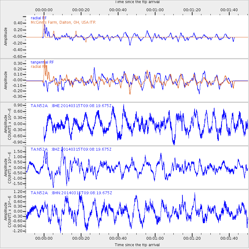
N52A McGinn's Farm, Dalton, OH, USA - Earthquake Result Viewer
*The percent match for this event was below the threshold and hence no stack was calculated.
| Earthquake location: |
Near Coast Of Peru |
| Earthquake latitude/longitude: |
-14.1/-76.3 |
| Earthquake time(UTC): |
2014/03/15 (074) 08:59:21 GMT |
| Earthquake Depth: |
20 km |
| Earthquake Magnitude: |
6.1 MWW, 6.0 MWB, 6.2 MWC |
| Earthquake Catalog/Contributor: |
NEIC PDE/NEIC COMCAT |
|
| Network: |
TA USArray Transportable Network (new EarthScope stations) |
| Station: |
N52A McGinn's Farm, Dalton, OH, USA |
| Lat/Lon: |
40.81 N/81.69 W |
| Elevation: |
331 m |
|
| Distance: |
54.9 deg |
| Az: |
355.01 deg |
| Baz: |
173.616 deg |
| Ray Param: |
$rayparam |
*The percent match for this event was below the threshold and hence was not used in the summary stack. |
|
| Radial Match: |
62.23444 % |
| Radial Bump: |
400 |
| Transverse Match: |
69.62186 % |
| Transverse Bump: |
400 |
| SOD ConfigId: |
626651 |
| Insert Time: |
2014-04-21 05:27:09.490 +0000 |
| GWidth: |
2.5 |
| Max Bumps: |
400 |
| Tol: |
0.001 |
|
Signal To Noise
| Channel | StoN | STA | LTA |
| TA:N52A: :BHZ:20140315T09:08:19.675Z | 3.3630764 | 8.315494E-7 | 2.4725853E-7 |
| TA:N52A: :BHN:20140315T09:08:19.675Z | 1.8232753 | 3.77822E-7 | 2.0722158E-7 |
| TA:N52A: :BHE:20140315T09:08:19.675Z | 1.1328864 | 3.2548573E-7 | 2.873066E-7 |
| Arrivals |
| Ps | |
| PpPs | |
| PsPs/PpSs | |


