You are here: Home > Network List > TA - USArray Transportable Network (new EarthScope stations) Stations List
> Station M63A Gales Ferry, CT, USA > Earthquake Result Viewer
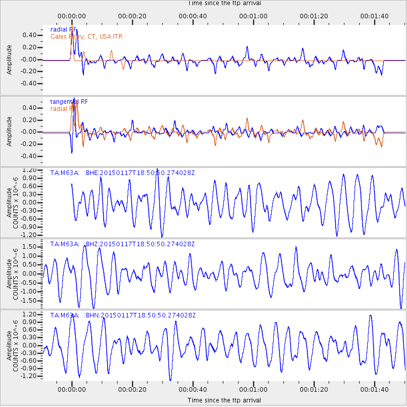
M63A Gales Ferry, CT, USA - Earthquake Result Viewer
*The percent match for this event was below the threshold and hence no stack was calculated.
| Earthquake location: |
Salta Province, Argentina |
| Earthquake latitude/longitude: |
-22.2/-63.1 |
| Earthquake time(UTC): |
2015/01/17 (017) 18:41:42 GMT |
| Earthquake Depth: |
557 km |
| Earthquake Magnitude: |
5.6 MWW, 5.6 MWB |
| Earthquake Catalog/Contributor: |
NEIC PDE/NEIC COMCAT |
|
| Network: |
TA USArray Transportable Network (new EarthScope stations) |
| Station: |
M63A Gales Ferry, CT, USA |
| Lat/Lon: |
41.40 N/72.05 W |
| Elevation: |
44 m |
|
| Distance: |
63.9 deg |
| Az: |
352.55 deg |
| Baz: |
170.811 deg |
| Ray Param: |
$rayparam |
*The percent match for this event was below the threshold and hence was not used in the summary stack. |
|
| Radial Match: |
56.652504 % |
| Radial Bump: |
400 |
| Transverse Match: |
54.78023 % |
| Transverse Bump: |
400 |
| SOD ConfigId: |
3390531 |
| Insert Time: |
2019-04-16 02:08:00.362 +0000 |
| GWidth: |
2.5 |
| Max Bumps: |
400 |
| Tol: |
0.001 |
|
Signal To Noise
| Channel | StoN | STA | LTA |
| TA:M63A: :BHZ:20150117T18:50:50.274028Z | 2.4874253 | 1.0349122E-6 | 4.160576E-7 |
| TA:M63A: :BHN:20150117T18:50:50.274028Z | 3.2119033 | 7.8621986E-7 | 2.4478317E-7 |
| TA:M63A: :BHE:20150117T18:50:50.274028Z | 1.5399978 | 6.2508326E-7 | 4.0589882E-7 |
| Arrivals |
| Ps | |
| PpPs | |
| PsPs/PpSs | |


