You are here: Home > Network List > TA - USArray Transportable Network (new EarthScope stations) Stations List
> Station MSTX Muleshoe, TX, USA > Earthquake Result Viewer
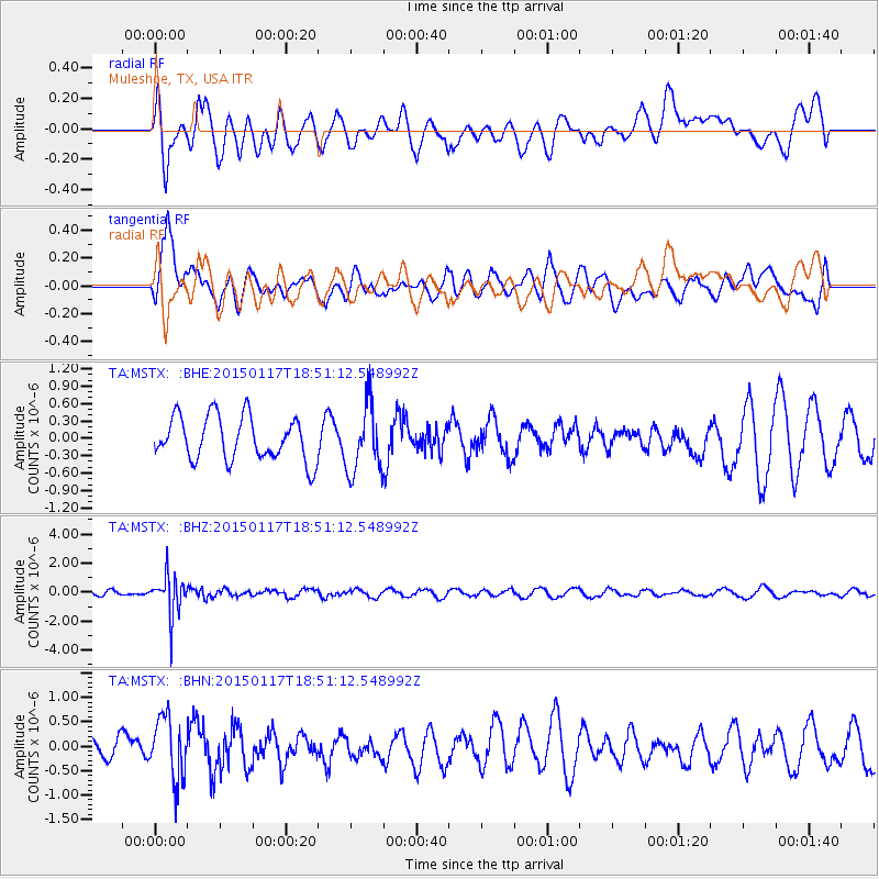
MSTX Muleshoe, TX, USA - Earthquake Result Viewer
*The percent match for this event was below the threshold and hence no stack was calculated.
| Earthquake location: |
Salta Province, Argentina |
| Earthquake latitude/longitude: |
-22.2/-63.1 |
| Earthquake time(UTC): |
2015/01/17 (017) 18:41:42 GMT |
| Earthquake Depth: |
557 km |
| Earthquake Magnitude: |
5.6 MWW, 5.6 MWB |
| Earthquake Catalog/Contributor: |
NEIC PDE/NEIC COMCAT |
|
| Network: |
TA USArray Transportable Network (new EarthScope stations) |
| Station: |
MSTX Muleshoe, TX, USA |
| Lat/Lon: |
33.97 N/102.77 W |
| Elevation: |
1167 m |
|
| Distance: |
67.4 deg |
| Az: |
324.971 deg |
| Baz: |
140.215 deg |
| Ray Param: |
$rayparam |
*The percent match for this event was below the threshold and hence was not used in the summary stack. |
|
| Radial Match: |
40.50821 % |
| Radial Bump: |
400 |
| Transverse Match: |
56.794426 % |
| Transverse Bump: |
400 |
| SOD ConfigId: |
3390531 |
| Insert Time: |
2019-04-16 02:08:07.943 +0000 |
| GWidth: |
2.5 |
| Max Bumps: |
400 |
| Tol: |
0.001 |
|
Signal To Noise
| Channel | StoN | STA | LTA |
| TA:MSTX: :BHZ:20150117T18:51:12.548992Z | 4.5404162 | 1.3538388E-6 | 2.9817505E-7 |
| TA:MSTX: :BHN:20150117T18:51:12.548992Z | 2.7213514 | 6.3387085E-7 | 2.3292502E-7 |
| TA:MSTX: :BHE:20150117T18:51:12.548992Z | 1.543468 | 5.784722E-7 | 3.747873E-7 |
| Arrivals |
| Ps | |
| PpPs | |
| PsPs/PpSs | |


