You are here: Home > Network List > TA - USArray Transportable Network (new EarthScope stations) Stations List
> Station Q59A Harwood, MD, USA > Earthquake Result Viewer
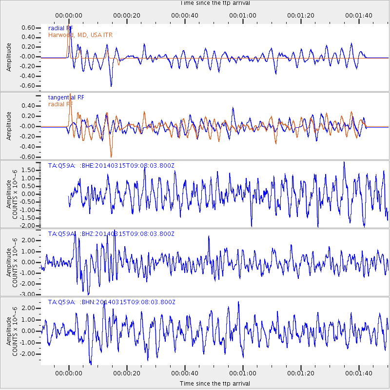
Q59A Harwood, MD, USA - Earthquake Result Viewer
*The percent match for this event was below the threshold and hence no stack was calculated.
| Earthquake location: |
Near Coast Of Peru |
| Earthquake latitude/longitude: |
-14.1/-76.3 |
| Earthquake time(UTC): |
2014/03/15 (074) 08:59:21 GMT |
| Earthquake Depth: |
20 km |
| Earthquake Magnitude: |
6.1 MWW, 6.0 MWB, 6.2 MWC |
| Earthquake Catalog/Contributor: |
NEIC PDE/NEIC COMCAT |
|
| Network: |
TA USArray Transportable Network (new EarthScope stations) |
| Station: |
Q59A Harwood, MD, USA |
| Lat/Lon: |
38.86 N/76.65 W |
| Elevation: |
34 m |
|
| Distance: |
52.7 deg |
| Az: |
359.66 deg |
| Baz: |
179.578 deg |
| Ray Param: |
$rayparam |
*The percent match for this event was below the threshold and hence was not used in the summary stack. |
|
| Radial Match: |
76.380196 % |
| Radial Bump: |
400 |
| Transverse Match: |
51.9134 % |
| Transverse Bump: |
400 |
| SOD ConfigId: |
626651 |
| Insert Time: |
2014-04-21 05:29:21.545 +0000 |
| GWidth: |
2.5 |
| Max Bumps: |
400 |
| Tol: |
0.001 |
|
Signal To Noise
| Channel | StoN | STA | LTA |
| TA:Q59A: :BHZ:20140315T09:08:03.800Z | 3.7766879 | 1.3389983E-6 | 3.5454303E-7 |
| TA:Q59A: :BHN:20140315T09:08:03.800Z | 1.0745265 | 6.1333634E-7 | 5.7079683E-7 |
| TA:Q59A: :BHE:20140315T09:08:03.800Z | 1.1791424 | 6.328293E-7 | 5.366861E-7 |
| Arrivals |
| Ps | |
| PpPs | |
| PsPs/PpSs | |


