You are here: Home > Network List > TA - USArray Transportable Network (new EarthScope stations) Stations List
> Station W57A Gilead, NC, USA > Earthquake Result Viewer
W57A Gilead, NC, USA - Earthquake Result Viewer

| Earthquake location: |
Salta Province, Argentina |
| Earthquake latitude/longitude: |
-22.2/-63.1 |
| Earthquake time(UTC): |
2015/01/17 (017) 18:41:42 GMT |
| Earthquake Depth: |
557 km |
| Earthquake Magnitude: |
5.6 MWW, 5.6 MWB |
| Earthquake Catalog/Contributor: |
NEIC PDE/NEIC COMCAT |
|
| Network: |
TA USArray Transportable Network (new EarthScope stations) |
| Station: |
W57A Gilead, NC, USA |
| Lat/Lon: |
35.15 N/79.99 W |
| Elevation: |
85 m |
|
| Distance: |
59.3 deg |
| Az: |
343.962 deg |
| Baz: |
161.798 deg |
| Ray Param: |
0.06007542 |
| Estimated Moho Depth: |
65.0 km |
| Estimated Crust Vp/Vs: |
1.62 |
| Assumed Crust Vp: |
6.565 km/s |
| Estimated Crust Vs: |
4.04 km/s |
| Estimated Crust Poisson's Ratio: |
0.20 |
|
| Radial Match: |
82.57671 % |
| Radial Bump: |
400 |
| Transverse Match: |
69.018486 % |
| Transverse Bump: |
400 |
| SOD ConfigId: |
3390531 |
| Insert Time: |
2019-04-16 02:08:32.106 +0000 |
| GWidth: |
2.5 |
| Max Bumps: |
400 |
| Tol: |
0.001 |
|
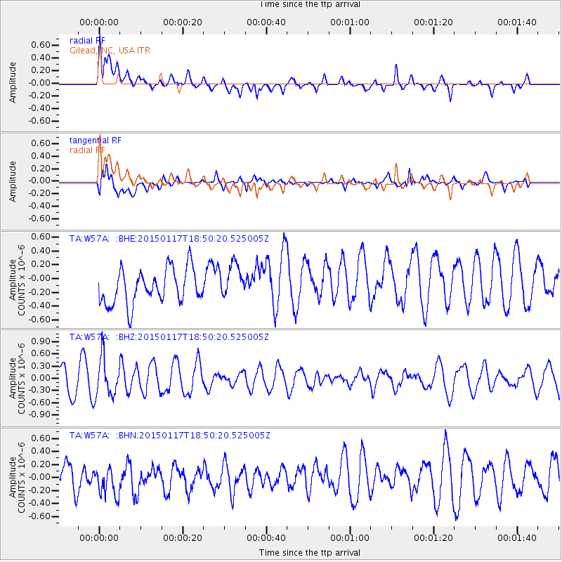
Signal To Noise
| Channel | StoN | STA | LTA |
| TA:W57A: :BHZ:20150117T18:50:20.525005Z | 1.2531362 | 4.6393214E-7 | 3.7021687E-7 |
| TA:W57A: :BHN:20150117T18:50:20.525005Z | 0.8000041 | 2.604699E-7 | 3.255857E-7 |
| TA:W57A: :BHE:20150117T18:50:20.525005Z | 1.0159717 | 2.5616328E-7 | 2.5213626E-7 |
| Arrivals |
| Ps | 6.5 SECOND |
| PpPs | 25 SECOND |
| PsPs/PpSs | 31 SECOND |


