You are here: Home > Network List > TA - USArray Transportable Network (new EarthScope stations) Stations List
> Station S49A Springfield, KY, USA > Earthquake Result Viewer
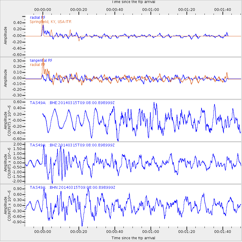
S49A Springfield, KY, USA - Earthquake Result Viewer
*The percent match for this event was below the threshold and hence no stack was calculated.
| Earthquake location: |
Near Coast Of Peru |
| Earthquake latitude/longitude: |
-14.1/-76.3 |
| Earthquake time(UTC): |
2014/03/15 (074) 08:59:21 GMT |
| Earthquake Depth: |
20 km |
| Earthquake Magnitude: |
6.1 MWW, 6.0 MWB, 6.2 MWC |
| Earthquake Catalog/Contributor: |
NEIC PDE/NEIC COMCAT |
|
| Network: |
TA USArray Transportable Network (new EarthScope stations) |
| Station: |
S49A Springfield, KY, USA |
| Lat/Lon: |
37.78 N/85.29 W |
| Elevation: |
230 m |
|
| Distance: |
52.3 deg |
| Az: |
351.008 deg |
| Baz: |
168.965 deg |
| Ray Param: |
$rayparam |
*The percent match for this event was below the threshold and hence was not used in the summary stack. |
|
| Radial Match: |
62.975304 % |
| Radial Bump: |
400 |
| Transverse Match: |
30.329824 % |
| Transverse Bump: |
361 |
| SOD ConfigId: |
626651 |
| Insert Time: |
2014-04-21 05:30:02.812 +0000 |
| GWidth: |
2.5 |
| Max Bumps: |
400 |
| Tol: |
0.001 |
|
Signal To Noise
| Channel | StoN | STA | LTA |
| TA:S49A: :BHZ:20140315T09:08:00.898999Z | 3.7455263 | 9.710062E-7 | 2.5924427E-7 |
| TA:S49A: :BHN:20140315T09:08:00.898999Z | 2.8596566 | 5.10598E-7 | 1.785522E-7 |
| TA:S49A: :BHE:20140315T09:08:00.898999Z | 0.92032456 | 1.9296594E-7 | 2.0967163E-7 |
| Arrivals |
| Ps | |
| PpPs | |
| PsPs/PpSs | |


