You are here: Home > Network List > TA - USArray Transportable Network (new EarthScope stations) Stations List
> Station X55A Gracelyn & Ava, Whitmire, SC, USA > Earthquake Result Viewer
X55A Gracelyn & Ava, Whitmire, SC, USA - Earthquake Result Viewer

| Earthquake location: |
Near Coast Of Peru |
| Earthquake latitude/longitude: |
-14.1/-76.3 |
| Earthquake time(UTC): |
2014/03/15 (074) 08:59:21 GMT |
| Earthquake Depth: |
20 km |
| Earthquake Magnitude: |
6.1 MWW, 6.0 MWB, 6.2 MWC |
| Earthquake Catalog/Contributor: |
NEIC PDE/NEIC COMCAT |
|
| Network: |
TA USArray Transportable Network (new EarthScope stations) |
| Station: |
X55A Gracelyn & Ava, Whitmire, SC, USA |
| Lat/Lon: |
34.47 N/81.63 W |
| Elevation: |
153 m |
|
| Distance: |
48.6 deg |
| Az: |
354.13 deg |
| Baz: |
173.101 deg |
| Ray Param: |
0.069253415 |
| Estimated Moho Depth: |
11.25 km |
| Estimated Crust Vp/Vs: |
2.10 |
| Assumed Crust Vp: |
6.419 km/s |
| Estimated Crust Vs: |
3.06 km/s |
| Estimated Crust Poisson's Ratio: |
0.35 |
|
| Radial Match: |
80.86154 % |
| Radial Bump: |
400 |
| Transverse Match: |
54.762844 % |
| Transverse Bump: |
400 |
| SOD ConfigId: |
626651 |
| Insert Time: |
2014-04-21 05:32:37.170 +0000 |
| GWidth: |
2.5 |
| Max Bumps: |
400 |
| Tol: |
0.001 |
|
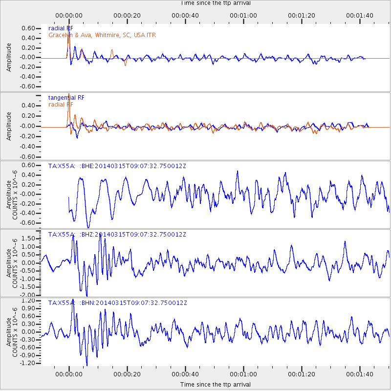
Signal To Noise
| Channel | StoN | STA | LTA |
| TA:X55A: :BHZ:20140315T09:07:32.750012Z | 2.2037525 | 9.682118E-7 | 4.3934685E-7 |
| TA:X55A: :BHN:20140315T09:07:32.750012Z | 3.5759077 | 5.600279E-7 | 1.566114E-7 |
| TA:X55A: :BHE:20140315T09:07:32.750012Z | 0.5471531 | 1.5899391E-7 | 2.9058398E-7 |
| Arrivals |
| Ps | 2.0 SECOND |
| PpPs | 5.2 SECOND |
| PsPs/PpSs | 7.2 SECOND |


