You are here: Home > Network List > US - United States National Seismic Network Stations List
> Station ELK Elko, Nevada, USA > Earthquake Result Viewer
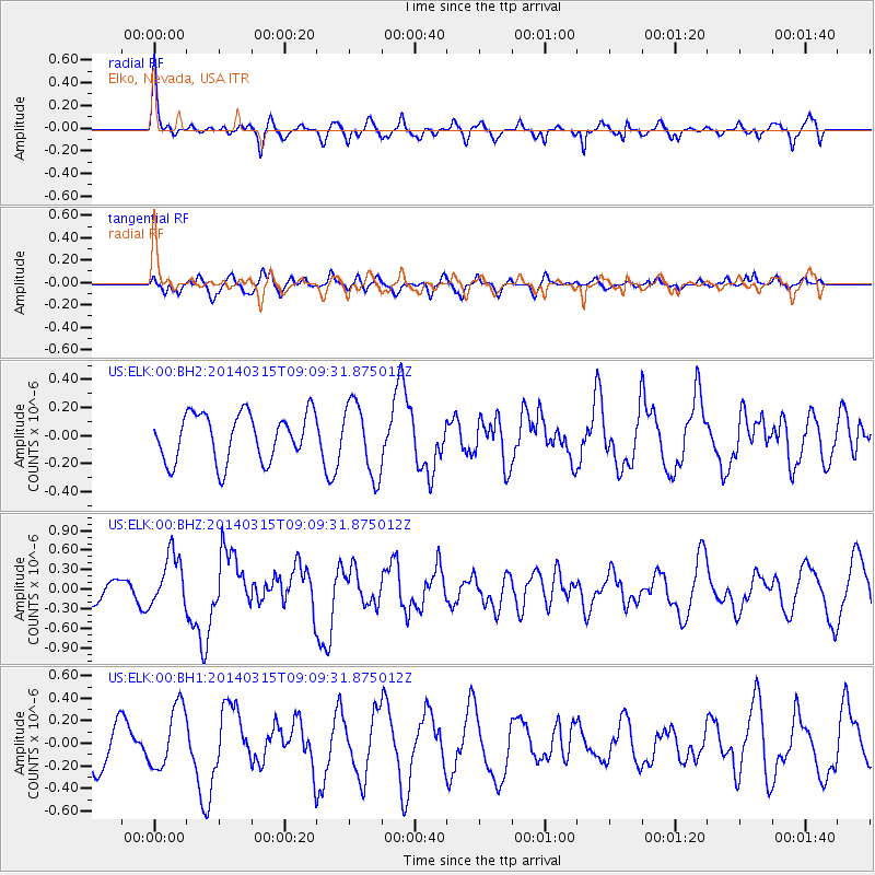
ELK Elko, Nevada, USA - Earthquake Result Viewer
*The percent match for this event was below the threshold and hence no stack was calculated.
| Earthquake location: |
Near Coast Of Peru |
| Earthquake latitude/longitude: |
-14.1/-76.3 |
| Earthquake time(UTC): |
2014/03/15 (074) 08:59:21 GMT |
| Earthquake Depth: |
20 km |
| Earthquake Magnitude: |
6.1 MWW, 6.0 MWB, 6.2 MWC |
| Earthquake Catalog/Contributor: |
NEIC PDE/NEIC COMCAT |
|
| Network: |
US United States National Seismic Network |
| Station: |
ELK Elko, Nevada, USA |
| Lat/Lon: |
40.74 N/115.24 W |
| Elevation: |
2210 m |
|
| Distance: |
65.4 deg |
| Az: |
328.329 deg |
| Baz: |
137.894 deg |
| Ray Param: |
$rayparam |
*The percent match for this event was below the threshold and hence was not used in the summary stack. |
|
| Radial Match: |
59.742245 % |
| Radial Bump: |
368 |
| Transverse Match: |
65.917595 % |
| Transverse Bump: |
400 |
| SOD ConfigId: |
626651 |
| Insert Time: |
2014-04-21 05:34:10.089 +0000 |
| GWidth: |
2.5 |
| Max Bumps: |
400 |
| Tol: |
0.001 |
|
Signal To Noise
| Channel | StoN | STA | LTA |
| US:ELK:00:BHZ:20140315T09:09:31.875012Z | 2.9782002 | 4.0261042E-7 | 1.3518581E-7 |
| US:ELK:00:BH1:20140315T09:09:31.875012Z | 1.5627036 | 2.7686573E-7 | 1.7717097E-7 |
| US:ELK:00:BH2:20140315T09:09:31.875012Z | 1.5245001 | 2.5785044E-7 | 1.691377E-7 |
| Arrivals |
| Ps | |
| PpPs | |
| PsPs/PpSs | |


