You are here: Home > Network List > US - United States National Seismic Network Stations List
> Station ERPA Erie, Pennsylvania, USA > Earthquake Result Viewer
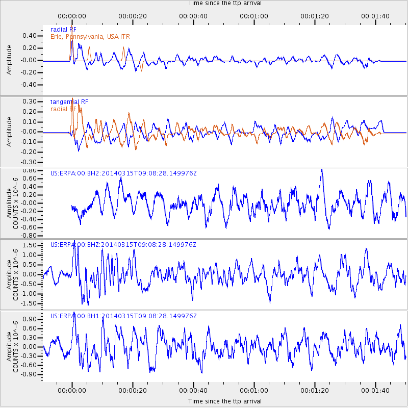
ERPA Erie, Pennsylvania, USA - Earthquake Result Viewer
*The percent match for this event was below the threshold and hence no stack was calculated.
| Earthquake location: |
Near Coast Of Peru |
| Earthquake latitude/longitude: |
-14.1/-76.3 |
| Earthquake time(UTC): |
2014/03/15 (074) 08:59:21 GMT |
| Earthquake Depth: |
20 km |
| Earthquake Magnitude: |
6.1 MWW, 6.0 MWB, 6.2 MWC |
| Earthquake Catalog/Contributor: |
NEIC PDE/NEIC COMCAT |
|
| Network: |
US United States National Seismic Network |
| Station: |
ERPA Erie, Pennsylvania, USA |
| Lat/Lon: |
42.12 N/79.99 W |
| Elevation: |
306 m |
|
| Distance: |
56.0 deg |
| Az: |
356.699 deg |
| Baz: |
175.693 deg |
| Ray Param: |
$rayparam |
*The percent match for this event was below the threshold and hence was not used in the summary stack. |
|
| Radial Match: |
65.35099 % |
| Radial Bump: |
398 |
| Transverse Match: |
60.336433 % |
| Transverse Bump: |
400 |
| SOD ConfigId: |
626651 |
| Insert Time: |
2014-04-21 05:34:12.418 +0000 |
| GWidth: |
2.5 |
| Max Bumps: |
400 |
| Tol: |
0.001 |
|
Signal To Noise
| Channel | StoN | STA | LTA |
| US:ERPA:00:BHZ:20140315T09:08:28.149976Z | 2.9140005 | 8.8655185E-7 | 3.0423874E-7 |
| US:ERPA:00:BH1:20140315T09:08:28.149976Z | 2.3842015 | 5.1247525E-7 | 2.1494627E-7 |
| US:ERPA:00:BH2:20140315T09:08:28.149976Z | 1.0572975 | 2.5148776E-7 | 2.3785904E-7 |
| Arrivals |
| Ps | |
| PpPs | |
| PsPs/PpSs | |


