You are here: Home > Network List > US - United States National Seismic Network Stations List
> Station TZTN Tazewell, Tennessee, USA > Earthquake Result Viewer
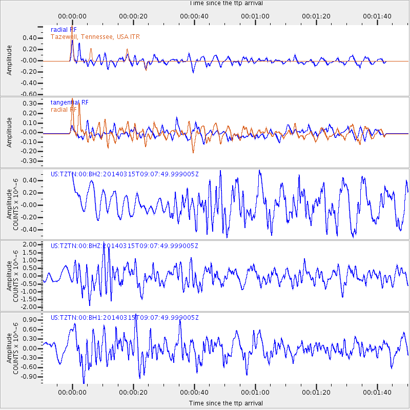
TZTN Tazewell, Tennessee, USA - Earthquake Result Viewer
*The percent match for this event was below the threshold and hence no stack was calculated.
| Earthquake location: |
Near Coast Of Peru |
| Earthquake latitude/longitude: |
-14.1/-76.3 |
| Earthquake time(UTC): |
2014/03/15 (074) 08:59:21 GMT |
| Earthquake Depth: |
20 km |
| Earthquake Magnitude: |
6.1 MWW, 6.0 MWB, 6.2 MWC |
| Earthquake Catalog/Contributor: |
NEIC PDE/NEIC COMCAT |
|
| Network: |
US United States National Seismic Network |
| Station: |
TZTN Tazewell, Tennessee, USA |
| Lat/Lon: |
36.54 N/83.55 W |
| Elevation: |
394 m |
|
| Distance: |
50.8 deg |
| Az: |
352.477 deg |
| Baz: |
170.925 deg |
| Ray Param: |
$rayparam |
*The percent match for this event was below the threshold and hence was not used in the summary stack. |
|
| Radial Match: |
62.807205 % |
| Radial Bump: |
400 |
| Transverse Match: |
58.91224 % |
| Transverse Bump: |
400 |
| SOD ConfigId: |
626651 |
| Insert Time: |
2014-04-21 05:35:14.604 +0000 |
| GWidth: |
2.5 |
| Max Bumps: |
400 |
| Tol: |
0.001 |
|
Signal To Noise
| Channel | StoN | STA | LTA |
| US:TZTN:00:BHZ:20140315T09:07:49.999005Z | 2.7096844 | 6.096928E-7 | 2.250051E-7 |
| US:TZTN:00:BH1:20140315T09:07:49.999005Z | 2.8236356 | 5.726543E-7 | 2.0280744E-7 |
| US:TZTN:00:BH2:20140315T09:07:49.999005Z | 0.95843846 | 1.659888E-7 | 1.731867E-7 |
| Arrivals |
| Ps | |
| PpPs | |
| PsPs/PpSs | |


