You are here: Home > Network List > XL12 - Hangay Dome, Mongolia Stations List
> Station AT04 AT04 > Earthquake Result Viewer
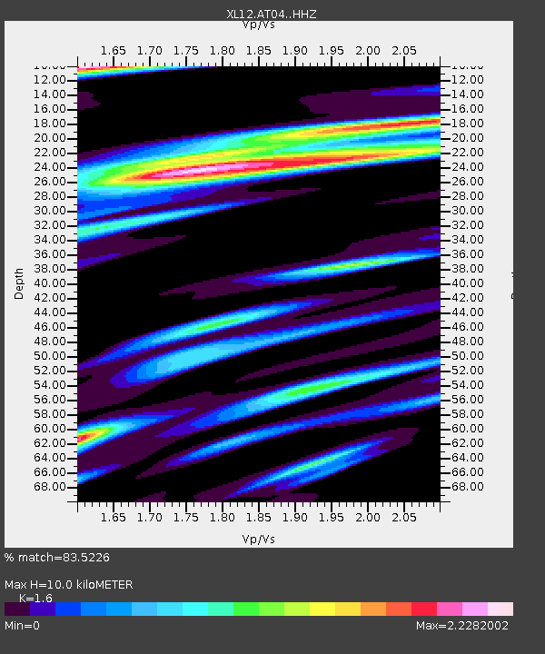
AT04 AT04 - Earthquake Result Viewer
| Earthquake location: |
Banda Sea |
| Earthquake latitude/longitude: |
-5.8/131.8 |
| Earthquake time(UTC): |
2015/01/17 (017) 23:39:52 GMT |
| Earthquake Depth: |
63 km |
| Earthquake Magnitude: |
5.6 MB |
| Earthquake Catalog/Contributor: |
NEIC PDE/NEIC COMCAT |
|
| Network: |
XL Hangay Dome, Mongolia |
| Station: |
AT04 AT04 |
| Lat/Lon: |
46.27 N/95.27 E |
| Elevation: |
1020 m |
|
| Distance: |
61.2 deg |
| Az: |
331.844 deg |
| Baz: |
137.402 deg |
| Ray Param: |
0.060900863 |
| Estimated Moho Depth: |
10.0 km |
| Estimated Crust Vp/Vs: |
1.60 |
| Assumed Crust Vp: |
6.642 km/s |
| Estimated Crust Vs: |
4.151 km/s |
| Estimated Crust Poisson's Ratio: |
0.18 |
|
| Radial Match: |
83.5226 % |
| Radial Bump: |
400 |
| Transverse Match: |
66.667015 % |
| Transverse Bump: |
400 |
| SOD ConfigId: |
3390531 |
| Insert Time: |
2019-04-16 02:14:27.827 +0000 |
| GWidth: |
2.5 |
| Max Bumps: |
400 |
| Tol: |
0.001 |
|

Signal To Noise
| Channel | StoN | STA | LTA |
| XL:AT04: :HHZ:20150117T23:49:29.438972Z | 4.0470214 | 3.3461563E-7 | 8.268195E-8 |
| XL:AT04: :HHN:20150117T23:49:29.438972Z | 1.2671379 | 1.845873E-7 | 1.4567262E-7 |
| XL:AT04: :HHE:20150117T23:49:29.438972Z | 1.6718305 | 1.8923873E-7 | 1.13192534E-7 |
| Arrivals |
| Ps | 1.0 SECOND |
| PpPs | 3.7 SECOND |
| PsPs/PpSs | 4.7 SECOND |


