You are here: Home > Network List > TA - USArray Transportable Network (new EarthScope stations) Stations List
> Station H46A Fife Lake, MI, USA > Earthquake Result Viewer
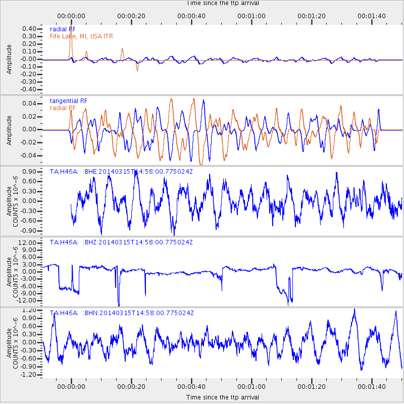
H46A Fife Lake, MI, USA - Earthquake Result Viewer
*The percent match for this event was below the threshold and hence no stack was calculated.
| Earthquake location: |
Near Coast Of Central Chile |
| Earthquake latitude/longitude: |
-34.7/-71.8 |
| Earthquake time(UTC): |
2014/03/15 (074) 14:46:28 GMT |
| Earthquake Depth: |
45 km |
| Earthquake Magnitude: |
5.5 MB, 5.1 MWW |
| Earthquake Catalog/Contributor: |
NEIC PDE/NEIC COMCAT |
|
| Network: |
TA USArray Transportable Network (new EarthScope stations) |
| Station: |
H46A Fife Lake, MI, USA |
| Lat/Lon: |
44.54 N/85.20 W |
| Elevation: |
329 m |
|
| Distance: |
79.8 deg |
| Az: |
350.293 deg |
| Baz: |
168.804 deg |
| Ray Param: |
$rayparam |
*The percent match for this event was below the threshold and hence was not used in the summary stack. |
|
| Radial Match: |
57.523922 % |
| Radial Bump: |
400 |
| Transverse Match: |
55.307896 % |
| Transverse Bump: |
400 |
| SOD ConfigId: |
626651 |
| Insert Time: |
2014-04-21 06:02:06.705 +0000 |
| GWidth: |
2.5 |
| Max Bumps: |
400 |
| Tol: |
0.001 |
|
Signal To Noise
| Channel | StoN | STA | LTA |
| TA:H46A: :BHZ:20140315T14:58:00.775024Z | 5.947211 | 6.3127995E-6 | 1.0614724E-6 |
| TA:H46A: :BHN:20140315T14:58:00.775024Z | 0.7418543 | 2.6258752E-7 | 3.5396104E-7 |
| TA:H46A: :BHE:20140315T14:58:00.775024Z | 1.0995804 | 4.995712E-7 | 4.5432887E-7 |
| Arrivals |
| Ps | |
| PpPs | |
| PsPs/PpSs | |


