You are here: Home > Network List > TA - USArray Transportable Network (new EarthScope stations) Stations List
> Station I48A Sherman Twp, MI, USA > Earthquake Result Viewer
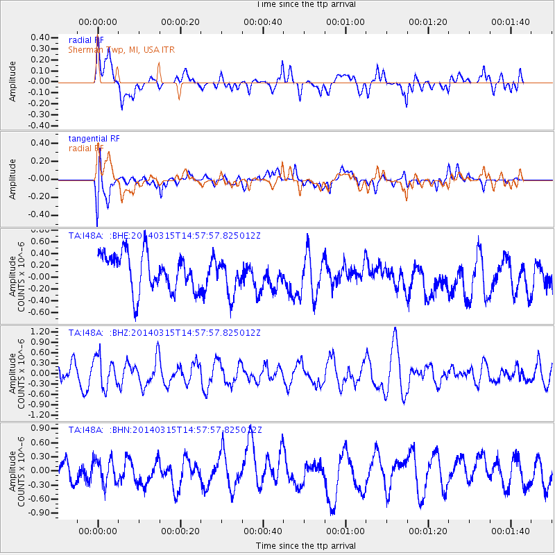
I48A Sherman Twp, MI, USA - Earthquake Result Viewer
*The percent match for this event was below the threshold and hence no stack was calculated.
| Earthquake location: |
Near Coast Of Central Chile |
| Earthquake latitude/longitude: |
-34.7/-71.8 |
| Earthquake time(UTC): |
2014/03/15 (074) 14:46:28 GMT |
| Earthquake Depth: |
45 km |
| Earthquake Magnitude: |
5.5 MB, 5.1 MWW |
| Earthquake Catalog/Contributor: |
NEIC PDE/NEIC COMCAT |
|
| Network: |
TA USArray Transportable Network (new EarthScope stations) |
| Station: |
I48A Sherman Twp, MI, USA |
| Lat/Lon: |
44.19 N/83.70 W |
| Elevation: |
192 m |
|
| Distance: |
79.3 deg |
| Az: |
351.304 deg |
| Baz: |
170.033 deg |
| Ray Param: |
$rayparam |
*The percent match for this event was below the threshold and hence was not used in the summary stack. |
|
| Radial Match: |
45.248478 % |
| Radial Bump: |
400 |
| Transverse Match: |
33.319397 % |
| Transverse Bump: |
400 |
| SOD ConfigId: |
626651 |
| Insert Time: |
2014-04-21 06:02:33.593 +0000 |
| GWidth: |
2.5 |
| Max Bumps: |
400 |
| Tol: |
0.001 |
|
Signal To Noise
| Channel | StoN | STA | LTA |
| TA:I48A: :BHZ:20140315T14:57:57.825012Z | 2.0499198 | 4.4518555E-7 | 2.1717217E-7 |
| TA:I48A: :BHN:20140315T14:57:57.825012Z | 0.96876484 | 2.587931E-7 | 2.6713718E-7 |
| TA:I48A: :BHE:20140315T14:57:57.825012Z | 0.9725987 | 3.0620427E-7 | 3.1483106E-7 |
| Arrivals |
| Ps | |
| PpPs | |
| PsPs/PpSs | |


