You are here: Home > Network List > KN - Kyrgyz Seismic Telemetry Network Stations List
> Station TKM2 - > Earthquake Result Viewer
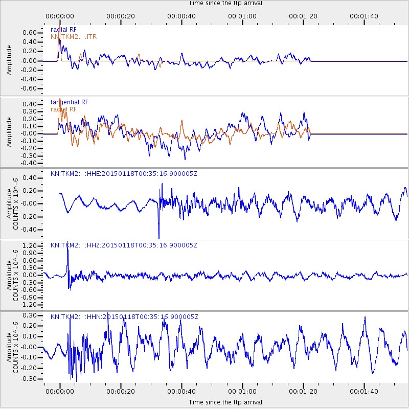
TKM2 - - Earthquake Result Viewer
*The percent match for this event was below the threshold and hence no stack was calculated.
| Earthquake location: |
Mindoro, Philippines |
| Earthquake latitude/longitude: |
13.9/120.6 |
| Earthquake time(UTC): |
2015/01/18 (018) 00:27:21 GMT |
| Earthquake Depth: |
140 km |
| Earthquake Magnitude: |
5.2 MW, 5.3 mb |
| Earthquake Catalog/Contributor: |
ISC/ISC |
|
| Network: |
KN Kyrgyz Seismic Telemetry Network |
| Station: |
TKM2 - |
| Lat/Lon: |
42.92 N/75.60 E |
| Elevation: |
2020 m |
|
| Distance: |
48.2 deg |
| Az: |
315.828 deg |
| Baz: |
112.908 deg |
| Ray Param: |
$rayparam |
*The percent match for this event was below the threshold and hence was not used in the summary stack. |
|
| Radial Match: |
67.90865 % |
| Radial Bump: |
400 |
| Transverse Match: |
49.319416 % |
| Transverse Bump: |
400 |
| SOD ConfigId: |
3390531 |
| Insert Time: |
2019-04-16 02:18:01.220 +0000 |
| GWidth: |
2.5 |
| Max Bumps: |
400 |
| Tol: |
0.001 |
|
Signal To Noise
| Channel | StoN | STA | LTA |
| KN:TKM2: :HHZ:20150118T00:35:16.900005Z | 4.253249 | 3.1728442E-7 | 7.459813E-8 |
| KN:TKM2: :HHN:20150118T00:35:16.900005Z | 1.5612173 | 1.3007235E-7 | 8.3314696E-8 |
| KN:TKM2: :HHE:20150118T00:35:16.900005Z | 1.840575 | 1.2519354E-7 | 6.801871E-8 |
| Arrivals |
| Ps | |
| PpPs | |
| PsPs/PpSs | |


