You are here: Home > Network List > AG - Arkansas Seismic Network Stations List
> Station WHAR Woolly Hollow State Park,AR > Earthquake Result Viewer
WHAR Woolly Hollow State Park,AR - Earthquake Result Viewer
| Earthquake location: |
Near Coast Of Northern Peru |
| Earthquake latitude/longitude: |
-5.6/-81.0 |
| Earthquake time(UTC): |
2014/03/15 (074) 23:51:33 GMT |
| Earthquake Depth: |
29 km |
| Earthquake Magnitude: |
6.3 MWW, 6.2 MWB, 6.3 MWC |
| Earthquake Catalog/Contributor: |
NEIC PDE/NEIC COMCAT |
|
| Network: |
AG Arkansas Seismic Network |
| Station: |
WHAR Woolly Hollow State Park,AR |
| Lat/Lon: |
35.29 N/92.29 W |
| Elevation: |
184 m |
|
| Distance: |
42.0 deg |
| Az: |
346.107 deg |
| Baz: |
163.014 deg |
| Ray Param: |
0.07336043 |
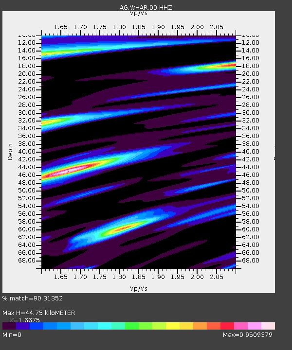
| Estimated Moho Depth: |
44.75 km |
| Estimated Crust Vp/Vs: |
1.67 |
| Assumed Crust Vp: |
6.498 km/s |
| Estimated Crust Vs: |
3.897 km/s |
| Estimated Crust Poisson's Ratio: |
0.22 |
|
| Radial Match: |
90.31352 % |
| Radial Bump: |
367 |
| Transverse Match: |
79.21521 % |
| Transverse Bump: |
400 |
| SOD ConfigId: |
626651 |
| Insert Time: |
2014-04-21 06:12:21.328 +0000 |
| GWidth: |
2.5 |
| Max Bumps: |
400 |
| Tol: |
0.001 |
|

Signal To Noise
| Channel | StoN | STA | LTA |
| AG:WHAR:00:HHZ:20140315T23:58:51.244987Z | 6.4548564 | 9.805193E-7 | 1.5190413E-7 |
| AG:WHAR:00:HHN:20140315T23:58:51.244987Z | 3.011766 | 4.5758458E-7 | 1.5193233E-7 |
| AG:WHAR:00:HHE:20140315T23:58:51.244987Z | 1.0839839 | 1.4345316E-7 | 1.3233883E-7 |
| Arrivals |
| Ps | 5.0 SECOND |
| PpPs | 17 SECOND |
| PsPs/PpSs | 22 SECOND |


