You are here: Home > Network List > GH - Ghana Digital Seismic Network Stations List
> Station WEIJ Weija Dam, Ghana > Earthquake Result Viewer
WEIJ Weija Dam, Ghana - Earthquake Result Viewer
| Earthquake location: |
Near Coast Of Northern Peru |
| Earthquake latitude/longitude: |
-5.6/-81.0 |
| Earthquake time(UTC): |
2014/03/15 (074) 23:51:33 GMT |
| Earthquake Depth: |
29 km |
| Earthquake Magnitude: |
6.3 MWW, 6.2 MWB, 6.3 MWC |
| Earthquake Catalog/Contributor: |
NEIC PDE/NEIC COMCAT |
|
| Network: |
GH Ghana Digital Seismic Network |
| Station: |
WEIJ Weija Dam, Ghana |
| Lat/Lon: |
5.59 N/0.33 W |
| Elevation: |
203 m |
|
| Distance: |
81.3 deg |
| Az: |
83.496 deg |
| Baz: |
263.504 deg |
| Ray Param: |
0.04767921 |
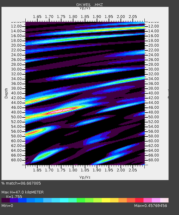
| Estimated Moho Depth: |
47.0 km |
| Estimated Crust Vp/Vs: |
1.75 |
| Assumed Crust Vp: |
6.472 km/s |
| Estimated Crust Vs: |
3.688 km/s |
| Estimated Crust Poisson's Ratio: |
0.26 |
|
| Radial Match: |
86.667885 % |
| Radial Bump: |
400 |
| Transverse Match: |
65.090164 % |
| Transverse Bump: |
400 |
| SOD ConfigId: |
626651 |
| Insert Time: |
2014-04-21 06:24:47.594 +0000 |
| GWidth: |
2.5 |
| Max Bumps: |
400 |
| Tol: |
0.001 |
|

Signal To Noise
| Channel | StoN | STA | LTA |
| GH:WEIJ: :HHZ:20140316T00:03:15.089988Z | 0.9696886 | 5.346865E-7 | 5.514002E-7 |
| GH:WEIJ: :HHN:20140316T00:03:15.089988Z | 0.693442 | 1.8867806E-7 | 2.7208918E-7 |
| GH:WEIJ: :HHE:20140316T00:03:15.089988Z | 1.4861403 | 1.2485349E-7 | 8.4011916E-8 |
| Arrivals |
| Ps | 5.6 SECOND |
| PpPs | 19 SECOND |
| PsPs/PpSs | 25 SECOND |


