You are here: Home > Network List > N4 - Central and EAstern US Network Stations List
> Station 553A Crawfordville, FL, USA > Earthquake Result Viewer
553A Crawfordville, FL, USA - Earthquake Result Viewer
| Earthquake location: |
Near Coast Of Northern Peru |
| Earthquake latitude/longitude: |
-5.6/-81.0 |
| Earthquake time(UTC): |
2014/03/15 (074) 23:51:33 GMT |
| Earthquake Depth: |
29 km |
| Earthquake Magnitude: |
6.3 MWW, 6.2 MWB, 6.3 MWC |
| Earthquake Catalog/Contributor: |
NEIC PDE/NEIC COMCAT |
|
| Network: |
N4 Central and EAstern US Network |
| Station: |
553A Crawfordville, FL, USA |
| Lat/Lon: |
30.19 N/84.43 W |
| Elevation: |
16 m |
|
| Distance: |
35.7 deg |
| Az: |
354.842 deg |
| Baz: |
174.068 deg |
| Ray Param: |
0.077021115 |
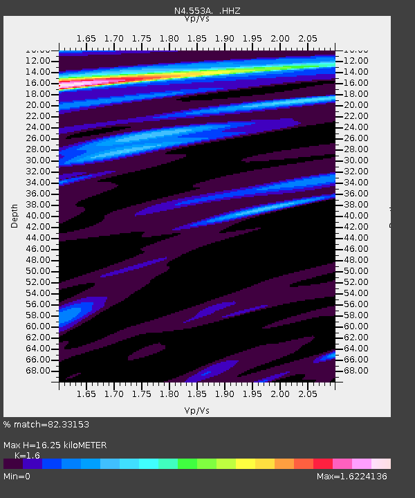
| Estimated Moho Depth: |
16.25 km |
| Estimated Crust Vp/Vs: |
1.60 |
| Assumed Crust Vp: |
6.347 km/s |
| Estimated Crust Vs: |
3.967 km/s |
| Estimated Crust Poisson's Ratio: |
0.18 |
|
| Radial Match: |
82.33153 % |
| Radial Bump: |
400 |
| Transverse Match: |
62.453804 % |
| Transverse Bump: |
400 |
| SOD ConfigId: |
626651 |
| Insert Time: |
2014-04-21 06:31:24.266 +0000 |
| GWidth: |
2.5 |
| Max Bumps: |
400 |
| Tol: |
0.001 |
|

Signal To Noise
| Channel | StoN | STA | LTA |
| N4:553A: :HHZ:20140315T23:57:58.52999Z | 2.8007655 | 9.851728E-7 | 3.5175128E-7 |
| N4:553A: :HHN:20140315T23:57:58.52999Z | 1.4068098 | 4.3083256E-7 | 3.062479E-7 |
| N4:553A: :HHE:20140315T23:57:58.52999Z | 0.92549276 | 2.7381384E-7 | 2.9585735E-7 |
| Arrivals |
| Ps | 1.7 SECOND |
| PpPs | 6.1 SECOND |
| PsPs/PpSs | 7.8 SECOND |


