You are here: Home > Network List > NM - Cooperative New Madrid Seismic Network Stations List
> Station GNAR Gosnell,AR > Earthquake Result Viewer
GNAR Gosnell,AR - Earthquake Result Viewer
| Earthquake location: |
Near Coast Of Northern Peru |
| Earthquake latitude/longitude: |
-5.6/-81.0 |
| Earthquake time(UTC): |
2014/03/15 (074) 23:51:33 GMT |
| Earthquake Depth: |
29 km |
| Earthquake Magnitude: |
6.3 MWW, 6.2 MWB, 6.3 MWC |
| Earthquake Catalog/Contributor: |
NEIC PDE/NEIC COMCAT |
|
| Network: |
NM Cooperative New Madrid Seismic Network |
| Station: |
GNAR Gosnell,AR |
| Lat/Lon: |
35.97 N/90.02 W |
| Elevation: |
71 m |
|
| Distance: |
42.2 deg |
| Az: |
349.033 deg |
| Baz: |
166.502 deg |
| Ray Param: |
0.073266305 |
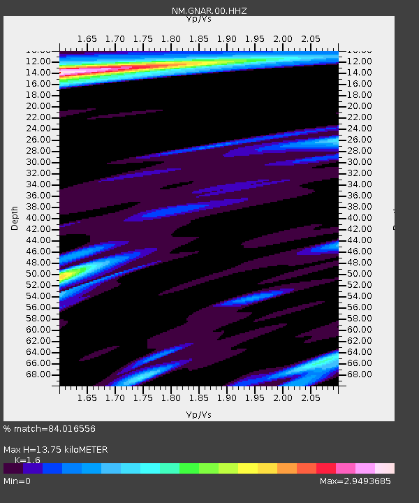
| Estimated Moho Depth: |
13.75 km |
| Estimated Crust Vp/Vs: |
1.60 |
| Assumed Crust Vp: |
6.273 km/s |
| Estimated Crust Vs: |
3.921 km/s |
| Estimated Crust Poisson's Ratio: |
0.18 |
|
| Radial Match: |
84.016556 % |
| Radial Bump: |
400 |
| Transverse Match: |
71.64117 % |
| Transverse Bump: |
400 |
| SOD ConfigId: |
626651 |
| Insert Time: |
2014-04-21 06:35:20.019 +0000 |
| GWidth: |
2.5 |
| Max Bumps: |
400 |
| Tol: |
0.001 |
|

Signal To Noise
| Channel | StoN | STA | LTA |
| NM:GNAR:00:HHZ:20140315T23:58:52.580009Z | 5.6671176 | 1.1116992E-6 | 1.9616661E-7 |
| NM:GNAR:00:HHN:20140315T23:58:52.580009Z | 1.1108271 | 5.63211E-7 | 5.070195E-7 |
| NM:GNAR:00:HHE:20140315T23:58:52.580009Z | 1.2762815 | 8.2468887E-7 | 6.4616535E-7 |
| Arrivals |
| Ps | 1.4 SECOND |
| PpPs | 5.3 SECOND |
| PsPs/PpSs | 6.7 SECOND |


