You are here: Home > Network List > NM - Cooperative New Madrid Seismic Network Stations List
> Station LPAR Lepanto,AR > Earthquake Result Viewer
LPAR Lepanto,AR - Earthquake Result Viewer
| Earthquake location: |
Near Coast Of Northern Peru |
| Earthquake latitude/longitude: |
-5.6/-81.0 |
| Earthquake time(UTC): |
2014/03/15 (074) 23:51:33 GMT |
| Earthquake Depth: |
29 km |
| Earthquake Magnitude: |
6.3 MWW, 6.2 MWB, 6.3 MWC |
| Earthquake Catalog/Contributor: |
NEIC PDE/NEIC COMCAT |
|
| Network: |
NM Cooperative New Madrid Seismic Network |
| Station: |
LPAR Lepanto,AR |
| Lat/Lon: |
35.60 N/90.30 W |
| Elevation: |
67 m |
|
| Distance: |
41.9 deg |
| Az: |
348.572 deg |
| Baz: |
165.996 deg |
| Ray Param: |
0.07344618 |
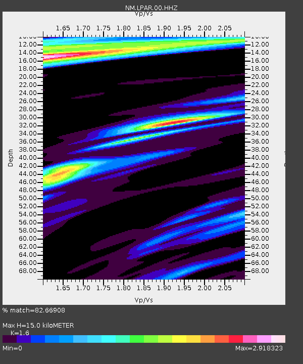
| Estimated Moho Depth: |
15.0 km |
| Estimated Crust Vp/Vs: |
1.60 |
| Assumed Crust Vp: |
6.273 km/s |
| Estimated Crust Vs: |
3.921 km/s |
| Estimated Crust Poisson's Ratio: |
0.18 |
|
| Radial Match: |
82.66908 % |
| Radial Bump: |
253 |
| Transverse Match: |
54.27788 % |
| Transverse Bump: |
358 |
| SOD ConfigId: |
626651 |
| Insert Time: |
2014-04-21 06:35:36.187 +0000 |
| GWidth: |
2.5 |
| Max Bumps: |
400 |
| Tol: |
0.001 |
|

Signal To Noise
| Channel | StoN | STA | LTA |
| NM:LPAR:00:HHZ:20140315T23:58:50.15499Z | 4.8655386 | 9.588614E-7 | 1.97072E-7 |
| NM:LPAR:00:HHN:20140315T23:58:50.15499Z | 1.4640889 | 8.3690276E-7 | 5.7162015E-7 |
| NM:LPAR:00:HHE:20140315T23:58:50.15499Z | 1.0093021 | 4.337302E-7 | 4.2973275E-7 |
| Arrivals |
| Ps | 1.5 SECOND |
| PpPs | 5.8 SECOND |
| PsPs/PpSs | 7.3 SECOND |


