You are here: Home > Network List > TA - USArray Transportable Network (new EarthScope stations) Stations List
> Station 157A Early Branch, SC, USA > Earthquake Result Viewer
157A Early Branch, SC, USA - Earthquake Result Viewer
| Earthquake location: |
Near Coast Of Northern Peru |
| Earthquake latitude/longitude: |
-5.6/-81.0 |
| Earthquake time(UTC): |
2014/03/15 (074) 23:51:33 GMT |
| Earthquake Depth: |
29 km |
| Earthquake Magnitude: |
6.3 MWW, 6.2 MWB, 6.3 MWC |
| Earthquake Catalog/Contributor: |
NEIC PDE/NEIC COMCAT |
|
| Network: |
TA USArray Transportable Network (new EarthScope stations) |
| Station: |
157A Early Branch, SC, USA |
| Lat/Lon: |
32.68 N/81.00 W |
| Elevation: |
21 m |
|
| Distance: |
38.0 deg |
| Az: |
359.944 deg |
| Baz: |
179.934 deg |
| Ray Param: |
0.07573599 |
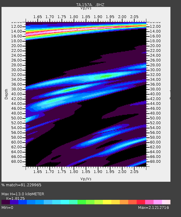
| Estimated Moho Depth: |
13.0 km |
| Estimated Crust Vp/Vs: |
1.81 |
| Assumed Crust Vp: |
6.565 km/s |
| Estimated Crust Vs: |
3.622 km/s |
| Estimated Crust Poisson's Ratio: |
0.28 |
|
| Radial Match: |
91.229965 % |
| Radial Bump: |
291 |
| Transverse Match: |
66.734695 % |
| Transverse Bump: |
400 |
| SOD ConfigId: |
626651 |
| Insert Time: |
2014-04-21 06:40:06.446 +0000 |
| GWidth: |
2.5 |
| Max Bumps: |
400 |
| Tol: |
0.001 |
|

Signal To Noise
| Channel | StoN | STA | LTA |
| TA:157A: :BHZ:20140315T23:58:18.274985Z | 3.5279822 | 9.3838895E-7 | 2.659846E-7 |
| TA:157A: :BHN:20140315T23:58:18.274985Z | 1.8053519 | 6.6004014E-7 | 3.6560195E-7 |
| TA:157A: :BHE:20140315T23:58:18.274985Z | 0.8160839 | 3.8644512E-7 | 4.73536E-7 |
| Arrivals |
| Ps | 1.7 SECOND |
| PpPs | 5.2 SECOND |
| PsPs/PpSs | 6.9 SECOND |


