You are here: Home > Network List > TA - USArray Transportable Network (new EarthScope stations) Stations List
> Station 833A Chaparral WMA, Artesia Wells, TX, USA > Earthquake Result Viewer
833A Chaparral WMA, Artesia Wells, TX, USA - Earthquake Result Viewer
| Earthquake location: |
Near Coast Of Northern Peru |
| Earthquake latitude/longitude: |
-5.6/-81.0 |
| Earthquake time(UTC): |
2014/03/15 (074) 23:51:33 GMT |
| Earthquake Depth: |
29 km |
| Earthquake Magnitude: |
6.3 MWW, 6.2 MWB, 6.3 MWC |
| Earthquake Catalog/Contributor: |
NEIC PDE/NEIC COMCAT |
|
| Network: |
TA USArray Transportable Network (new EarthScope stations) |
| Station: |
833A Chaparral WMA, Artesia Wells, TX, USA |
| Lat/Lon: |
28.32 N/99.39 W |
| Elevation: |
171 m |
|
| Distance: |
38.1 deg |
| Az: |
333.141 deg |
| Baz: |
149.331 deg |
| Ray Param: |
0.07570063 |
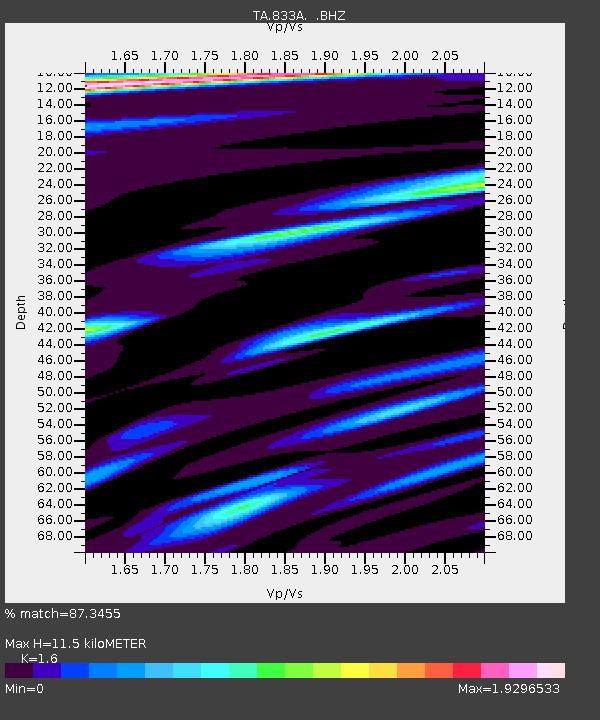
| Estimated Moho Depth: |
11.5 km |
| Estimated Crust Vp/Vs: |
1.60 |
| Assumed Crust Vp: |
6.347 km/s |
| Estimated Crust Vs: |
3.967 km/s |
| Estimated Crust Poisson's Ratio: |
0.18 |
|
| Radial Match: |
87.3455 % |
| Radial Bump: |
349 |
| Transverse Match: |
80.6129 % |
| Transverse Bump: |
400 |
| SOD ConfigId: |
626651 |
| Insert Time: |
2014-04-21 06:40:17.926 +0000 |
| GWidth: |
2.5 |
| Max Bumps: |
400 |
| Tol: |
0.001 |
|

Signal To Noise
| Channel | StoN | STA | LTA |
| TA:833A: :BHZ:20140315T23:58:18.774985Z | 7.540711 | 9.79434E-7 | 1.2988616E-7 |
| TA:833A: :BHN:20140315T23:58:18.774985Z | 3.1650054 | 4.4813686E-7 | 1.4159119E-7 |
| TA:833A: :BHE:20140315T23:58:18.774985Z | 3.2711253 | 3.7947166E-7 | 1.1600646E-7 |
| Arrivals |
| Ps | 1.2 SECOND |
| PpPs | 4.4 SECOND |
| PsPs/PpSs | 5.5 SECOND |


