You are here: Home > Network List > TA - USArray Transportable Network (new EarthScope stations) Stations List
> Station F48A Evansville, ON, CAN > Earthquake Result Viewer
F48A Evansville, ON, CAN - Earthquake Result Viewer
| Earthquake location: |
Near Coast Of Northern Peru |
| Earthquake latitude/longitude: |
-5.6/-81.0 |
| Earthquake time(UTC): |
2014/03/15 (074) 23:51:33 GMT |
| Earthquake Depth: |
29 km |
| Earthquake Magnitude: |
6.3 MWW, 6.2 MWB, 6.3 MWC |
| Earthquake Catalog/Contributor: |
NEIC PDE/NEIC COMCAT |
|
| Network: |
TA USArray Transportable Network (new EarthScope stations) |
| Station: |
F48A Evansville, ON, CAN |
| Lat/Lon: |
45.83 N/82.62 W |
| Elevation: |
203 m |
|
| Distance: |
51.2 deg |
| Az: |
358.509 deg |
| Baz: |
177.877 deg |
| Ray Param: |
0.067514375 |
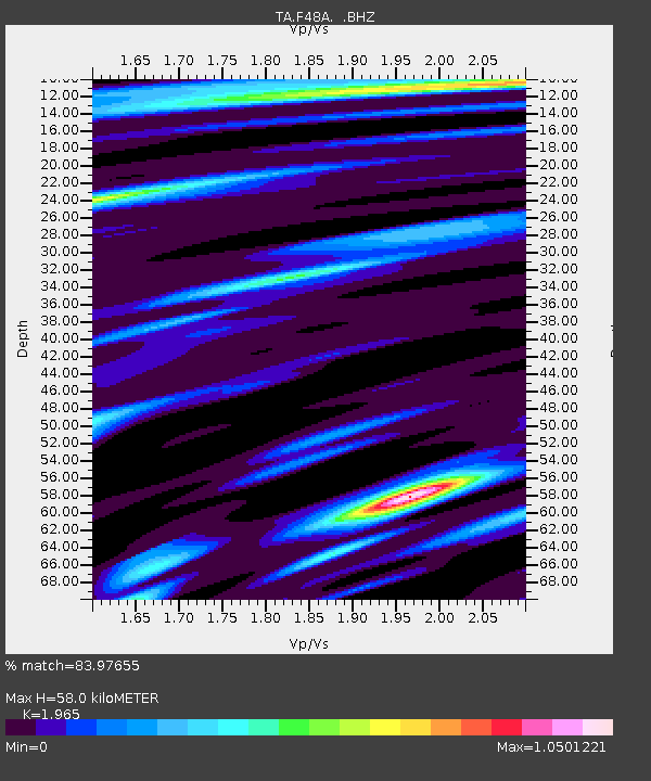
| Estimated Moho Depth: |
58.0 km |
| Estimated Crust Vp/Vs: |
1.97 |
| Assumed Crust Vp: |
6.483 km/s |
| Estimated Crust Vs: |
3.299 km/s |
| Estimated Crust Poisson's Ratio: |
0.33 |
|
| Radial Match: |
83.97655 % |
| Radial Bump: |
400 |
| Transverse Match: |
67.928856 % |
| Transverse Bump: |
400 |
| SOD ConfigId: |
626651 |
| Insert Time: |
2014-04-21 06:42:35.748 +0000 |
| GWidth: |
2.5 |
| Max Bumps: |
400 |
| Tol: |
0.001 |
|
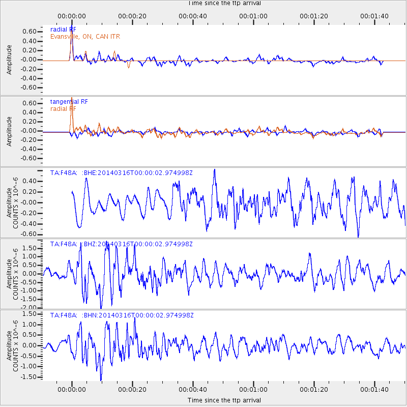
Signal To Noise
| Channel | StoN | STA | LTA |
| TA:F48A: :BHZ:20140316T00:00:02.974998Z | 3.882072 | 8.952213E-7 | 2.30604E-7 |
| TA:F48A: :BHN:20140316T00:00:02.974998Z | 4.773268 | 5.702692E-7 | 1.1947144E-7 |
| TA:F48A: :BHE:20140316T00:00:02.974998Z | 1.2527446 | 2.350446E-7 | 1.8762371E-7 |
| Arrivals |
| Ps | 9.1 SECOND |
| PpPs | 25 SECOND |
| PsPs/PpSs | 34 SECOND |


