You are here: Home > Network List > TA - USArray Transportable Network (new EarthScope stations) Stations List
> Station G62A West of Eustis, ME, USA > Earthquake Result Viewer
G62A West of Eustis, ME, USA - Earthquake Result Viewer
| Earthquake location: |
Near Coast Of Northern Peru |
| Earthquake latitude/longitude: |
-5.6/-81.0 |
| Earthquake time(UTC): |
2014/03/15 (074) 23:51:33 GMT |
| Earthquake Depth: |
29 km |
| Earthquake Magnitude: |
6.3 MWW, 6.2 MWB, 6.3 MWC |
| Earthquake Catalog/Contributor: |
NEIC PDE/NEIC COMCAT |
|
| Network: |
TA USArray Transportable Network (new EarthScope stations) |
| Station: |
G62A West of Eustis, ME, USA |
| Lat/Lon: |
45.22 N/70.53 W |
| Elevation: |
426 m |
|
| Distance: |
51.4 deg |
| Az: |
9.415 deg |
| Baz: |
193.318 deg |
| Ray Param: |
0.06737322 |
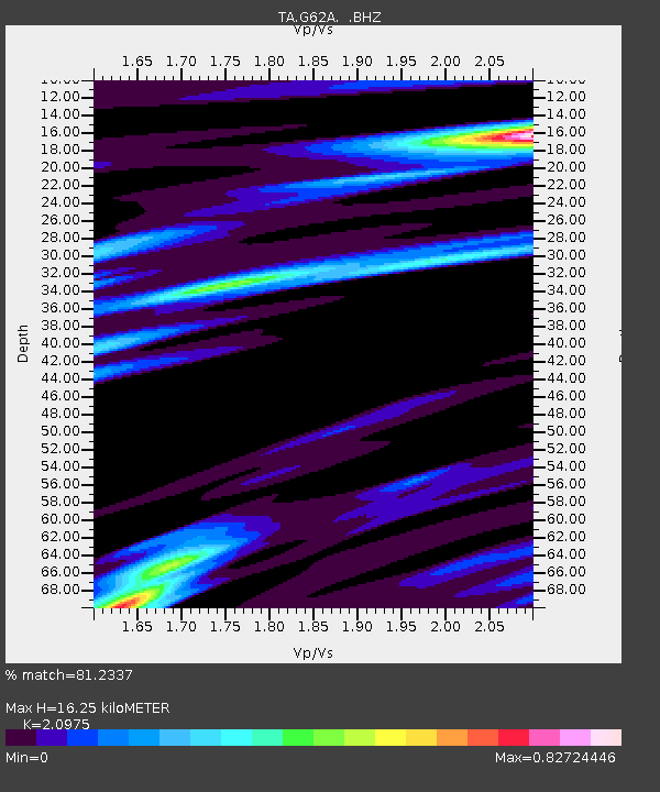
| Estimated Moho Depth: |
16.25 km |
| Estimated Crust Vp/Vs: |
2.10 |
| Assumed Crust Vp: |
6.419 km/s |
| Estimated Crust Vs: |
3.06 km/s |
| Estimated Crust Poisson's Ratio: |
0.35 |
|
| Radial Match: |
81.2337 % |
| Radial Bump: |
400 |
| Transverse Match: |
69.4524 % |
| Transverse Bump: |
400 |
| SOD ConfigId: |
626651 |
| Insert Time: |
2014-04-21 06:43:50.241 +0000 |
| GWidth: |
2.5 |
| Max Bumps: |
400 |
| Tol: |
0.001 |
|

Signal To Noise
| Channel | StoN | STA | LTA |
| TA:G62A: :BHZ:20140316T00:00:04.649985Z | 2.5378075 | 9.365505E-7 | 3.690392E-7 |
| TA:G62A: :BHN:20140316T00:00:04.649985Z | 1.3333348 | 3.3105863E-7 | 2.482937E-7 |
| TA:G62A: :BHE:20140316T00:00:04.649985Z | 1.0038116 | 2.8670425E-7 | 2.856156E-7 |
| Arrivals |
| Ps | 2.9 SECOND |
| PpPs | 7.5 SECOND |
| PsPs/PpSs | 10 SECOND |


