You are here: Home > Network List > TA - USArray Transportable Network (new EarthScope stations) Stations List
> Station I52A Shelburne, ON, CAN > Earthquake Result Viewer
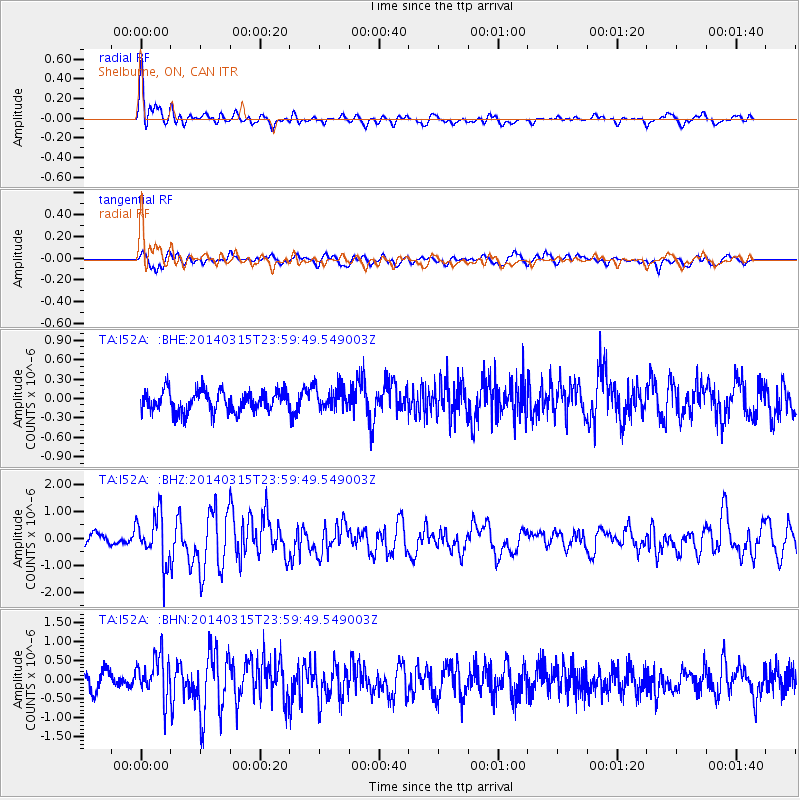
I52A Shelburne, ON, CAN - Earthquake Result Viewer
*The percent match for this event was below the threshold and hence no stack was calculated.
| Earthquake location: |
Near Coast Of Northern Peru |
| Earthquake latitude/longitude: |
-5.6/-81.0 |
| Earthquake time(UTC): |
2014/03/15 (074) 23:51:33 GMT |
| Earthquake Depth: |
29 km |
| Earthquake Magnitude: |
6.3 MWW, 6.2 MWB, 6.3 MWC |
| Earthquake Catalog/Contributor: |
NEIC PDE/NEIC COMCAT |
|
| Network: |
TA USArray Transportable Network (new EarthScope stations) |
| Station: |
I52A Shelburne, ON, CAN |
| Lat/Lon: |
44.07 N/80.18 W |
| Elevation: |
505 m |
|
| Distance: |
49.4 deg |
| Az: |
0.74 deg |
| Baz: |
181.021 deg |
| Ray Param: |
$rayparam |
*The percent match for this event was below the threshold and hence was not used in the summary stack. |
|
| Radial Match: |
71.664856 % |
| Radial Bump: |
400 |
| Transverse Match: |
62.82559 % |
| Transverse Bump: |
400 |
| SOD ConfigId: |
626651 |
| Insert Time: |
2014-04-21 06:45:35.769 +0000 |
| GWidth: |
2.5 |
| Max Bumps: |
400 |
| Tol: |
0.001 |
|
Signal To Noise
| Channel | StoN | STA | LTA |
| TA:I52A: :BHZ:20140315T23:59:49.549003Z | 4.5591946 | 9.2654454E-7 | 2.032255E-7 |
| TA:I52A: :BHN:20140315T23:59:49.549003Z | 2.396891 | 5.7641694E-7 | 2.4048524E-7 |
| TA:I52A: :BHE:20140315T23:59:49.549003Z | 1.1105694 | 1.8064253E-7 | 1.6265759E-7 |
| Arrivals |
| Ps | |
| PpPs | |
| PsPs/PpSs | |


