You are here: Home > Network List > TA - USArray Transportable Network (new EarthScope stations) Stations List
> Station J45A Montague, MI, USA > Earthquake Result Viewer
J45A Montague, MI, USA - Earthquake Result Viewer
| Earthquake location: |
Near Coast Of Northern Peru |
| Earthquake latitude/longitude: |
-5.6/-81.0 |
| Earthquake time(UTC): |
2014/03/15 (074) 23:51:33 GMT |
| Earthquake Depth: |
29 km |
| Earthquake Magnitude: |
6.3 MWW, 6.2 MWB, 6.3 MWC |
| Earthquake Catalog/Contributor: |
NEIC PDE/NEIC COMCAT |
|
| Network: |
TA USArray Transportable Network (new EarthScope stations) |
| Station: |
J45A Montague, MI, USA |
| Lat/Lon: |
43.44 N/86.39 W |
| Elevation: |
209 m |
|
| Distance: |
49.0 deg |
| Az: |
354.76 deg |
| Baz: |
172.831 deg |
| Ray Param: |
0.06891013 |
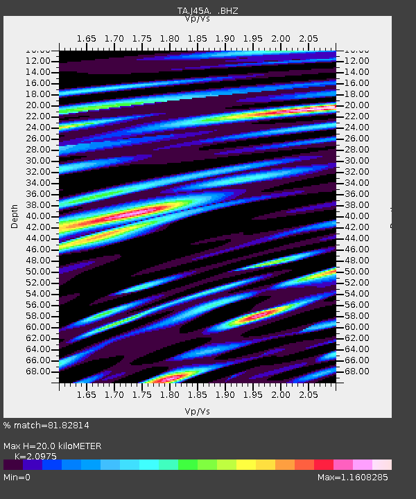
| Estimated Moho Depth: |
20.0 km |
| Estimated Crust Vp/Vs: |
2.10 |
| Assumed Crust Vp: |
6.483 km/s |
| Estimated Crust Vs: |
3.091 km/s |
| Estimated Crust Poisson's Ratio: |
0.35 |
|
| Radial Match: |
81.82814 % |
| Radial Bump: |
400 |
| Transverse Match: |
67.23794 % |
| Transverse Bump: |
400 |
| SOD ConfigId: |
626651 |
| Insert Time: |
2014-04-21 06:46:10.129 +0000 |
| GWidth: |
2.5 |
| Max Bumps: |
400 |
| Tol: |
0.001 |
|
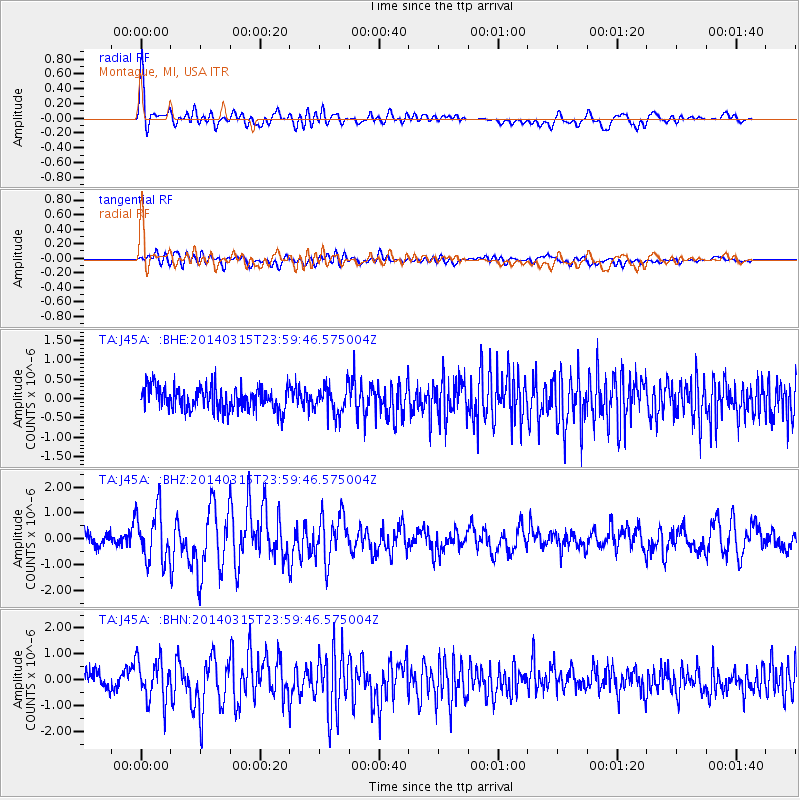
Signal To Noise
| Channel | StoN | STA | LTA |
| TA:J45A: :BHZ:20140315T23:59:46.575004Z | 4.420917 | 9.954083E-7 | 2.2515879E-7 |
| TA:J45A: :BHN:20140315T23:59:46.575004Z | 3.048062 | 8.295583E-7 | 2.7215924E-7 |
| TA:J45A: :BHE:20140315T23:59:46.575004Z | 1.2257977 | 3.6207746E-7 | 2.953811E-7 |
| Arrivals |
| Ps | 3.6 SECOND |
| PpPs | 9.1 SECOND |
| PsPs/PpSs | 13 SECOND |


