You are here: Home > Network List > TA - USArray Transportable Network (new EarthScope stations) Stations List
> Station L48A N Adams, MI, USA > Earthquake Result Viewer
L48A N Adams, MI, USA - Earthquake Result Viewer
| Earthquake location: |
Near Coast Of Northern Peru |
| Earthquake latitude/longitude: |
-5.6/-81.0 |
| Earthquake time(UTC): |
2014/03/15 (074) 23:51:33 GMT |
| Earthquake Depth: |
29 km |
| Earthquake Magnitude: |
6.3 MWW, 6.2 MWB, 6.3 MWC |
| Earthquake Catalog/Contributor: |
NEIC PDE/NEIC COMCAT |
|
| Network: |
TA USArray Transportable Network (new EarthScope stations) |
| Station: |
L48A N Adams, MI, USA |
| Lat/Lon: |
41.94 N/84.43 W |
| Elevation: |
369 m |
|
| Distance: |
47.4 deg |
| Az: |
356.477 deg |
| Baz: |
175.297 deg |
| Ray Param: |
0.069959424 |
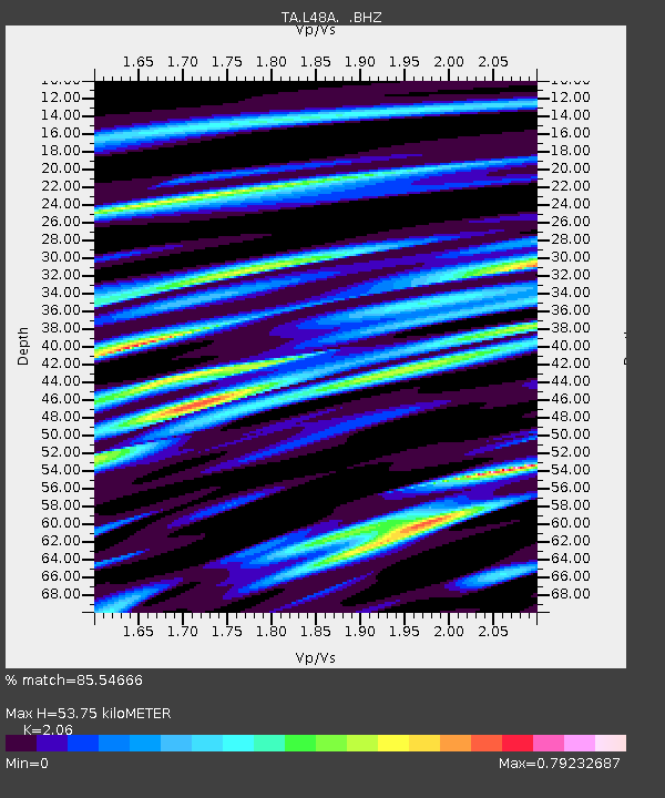
| Estimated Moho Depth: |
53.75 km |
| Estimated Crust Vp/Vs: |
2.06 |
| Assumed Crust Vp: |
6.498 km/s |
| Estimated Crust Vs: |
3.154 km/s |
| Estimated Crust Poisson's Ratio: |
0.35 |
|
| Radial Match: |
85.54666 % |
| Radial Bump: |
400 |
| Transverse Match: |
73.19117 % |
| Transverse Bump: |
400 |
| SOD ConfigId: |
626651 |
| Insert Time: |
2014-04-21 06:48:24.119 +0000 |
| GWidth: |
2.5 |
| Max Bumps: |
400 |
| Tol: |
0.001 |
|
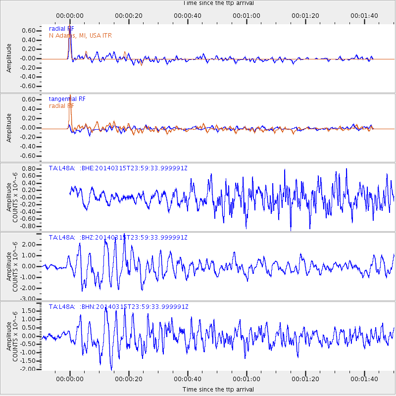
Signal To Noise
| Channel | StoN | STA | LTA |
| TA:L48A: :BHZ:20140315T23:59:33.999991Z | 6.8888416 | 1.1190468E-6 | 1.6244341E-7 |
| TA:L48A: :BHN:20140315T23:59:33.999991Z | 2.7816408 | 5.818075E-7 | 2.0915984E-7 |
| TA:L48A: :BHE:20140315T23:59:33.999991Z | 1.276839 | 1.8102835E-7 | 1.4177853E-7 |
| Arrivals |
| Ps | 9.3 SECOND |
| PpPs | 24 SECOND |
| PsPs/PpSs | 33 SECOND |


