You are here: Home > Network List > TA - USArray Transportable Network (new EarthScope stations) Stations List
> Station L54A Sinclairville, NY, USA > Earthquake Result Viewer
L54A Sinclairville, NY, USA - Earthquake Result Viewer
| Earthquake location: |
Near Coast Of Northern Peru |
| Earthquake latitude/longitude: |
-5.6/-81.0 |
| Earthquake time(UTC): |
2014/03/15 (074) 23:51:33 GMT |
| Earthquake Depth: |
29 km |
| Earthquake Magnitude: |
6.3 MWW, 6.2 MWB, 6.3 MWC |
| Earthquake Catalog/Contributor: |
NEIC PDE/NEIC COMCAT |
|
| Network: |
TA USArray Transportable Network (new EarthScope stations) |
| Station: |
L54A Sinclairville, NY, USA |
| Lat/Lon: |
42.23 N/79.32 W |
| Elevation: |
432 m |
|
| Distance: |
47.6 deg |
| Az: |
1.649 deg |
| Baz: |
182.211 deg |
| Ray Param: |
0.06982837 |
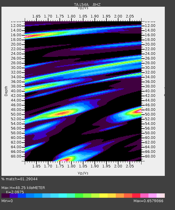
| Estimated Moho Depth: |
48.25 km |
| Estimated Crust Vp/Vs: |
2.10 |
| Assumed Crust Vp: |
6.419 km/s |
| Estimated Crust Vs: |
3.06 km/s |
| Estimated Crust Poisson's Ratio: |
0.35 |
|
| Radial Match: |
81.29044 % |
| Radial Bump: |
355 |
| Transverse Match: |
62.73285 % |
| Transverse Bump: |
400 |
| SOD ConfigId: |
626651 |
| Insert Time: |
2014-04-21 06:48:34.960 +0000 |
| GWidth: |
2.5 |
| Max Bumps: |
400 |
| Tol: |
0.001 |
|
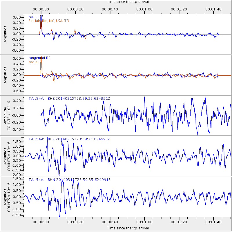
Signal To Noise
| Channel | StoN | STA | LTA |
| TA:L54A: :BHZ:20140315T23:59:35.624991Z | 4.1574183 | 8.1082993E-7 | 1.9503207E-7 |
| TA:L54A: :BHN:20140315T23:59:35.624991Z | 2.440963 | 4.723798E-7 | 1.9352191E-7 |
| TA:L54A: :BHE:20140315T23:59:35.624991Z | 0.9589153 | 1.3536199E-7 | 1.4116156E-7 |
| Arrivals |
| Ps | 8.7 SECOND |
| PpPs | 22 SECOND |
| PsPs/PpSs | 31 SECOND |


