You are here: Home > Network List > TA - USArray Transportable Network (new EarthScope stations) Stations List
> Station M48A Edgerton, OH, USA > Earthquake Result Viewer
M48A Edgerton, OH, USA - Earthquake Result Viewer

| Earthquake location: |
Near Coast Of Northern Peru |
| Earthquake latitude/longitude: |
-5.6/-81.0 |
| Earthquake time(UTC): |
2014/03/15 (074) 23:51:33 GMT |
| Earthquake Depth: |
29 km |
| Earthquake Magnitude: |
6.3 MWW, 6.2 MWB, 6.3 MWC |
| Earthquake Catalog/Contributor: |
NEIC PDE/NEIC COMCAT |
|
| Network: |
TA USArray Transportable Network (new EarthScope stations) |
| Station: |
M48A Edgerton, OH, USA |
| Lat/Lon: |
41.48 N/84.72 W |
| Elevation: |
258 m |
|
| Distance: |
47.0 deg |
| Az: |
356.134 deg |
| Baz: |
174.876 deg |
| Ray Param: |
0.07025157 |
| Estimated Moho Depth: |
23.0 km |
| Estimated Crust Vp/Vs: |
1.63 |
| Assumed Crust Vp: |
6.498 km/s |
| Estimated Crust Vs: |
3.992 km/s |
| Estimated Crust Poisson's Ratio: |
0.20 |
|
| Radial Match: |
85.015656 % |
| Radial Bump: |
400 |
| Transverse Match: |
61.29728 % |
| Transverse Bump: |
400 |
| SOD ConfigId: |
626651 |
| Insert Time: |
2014-04-21 06:49:22.106 +0000 |
| GWidth: |
2.5 |
| Max Bumps: |
400 |
| Tol: |
0.001 |
|
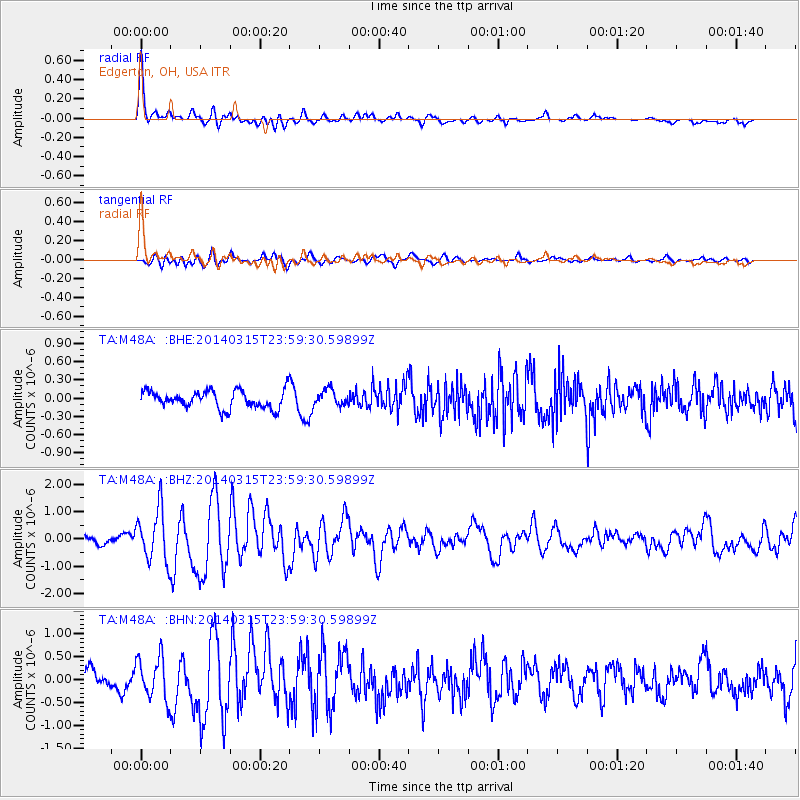
Signal To Noise
| Channel | StoN | STA | LTA |
| TA:M48A: :BHZ:20140315T23:59:30.59899Z | 6.5477066 | 9.5139677E-7 | 1.453023E-7 |
| TA:M48A: :BHN:20140315T23:59:30.59899Z | 2.395921 | 4.5890522E-7 | 1.9153605E-7 |
| TA:M48A: :BHE:20140315T23:59:30.59899Z | 0.8996966 | 1.2985087E-7 | 1.443274E-7 |
| Arrivals |
| Ps | 2.4 SECOND |
| PpPs | 8.7 SECOND |
| PsPs/PpSs | 11 SECOND |


